1970s Maps of Winter, Wisconsin
Explore 10 historic maps of Winter from the 1970s. These maps offer a rare glimpse into what life looked like during the 1970s — showing old roads, neighborhoods, homes, and landmarks that have changed or disappeared over time.
Whether you're researching your family's past, planning a metal detecting trip, or studying how Winter's landscape evolved across the 1970s, these high-resolution maps are a powerful tool for exploring the history of this region.
- Focus on a specific era: All maps on this page are from the 1970s, giving you a focused view of this time period.
- See what’s changed: Compare century-old streets, trails, and buildings to today's modern landscape using overlays and satellite layers.
- Research with precision: Use these maps for genealogy, historical research, land use analysis, or educational projects.
- View, download, or print: Maps are fully viewable online in high resolution, and can be downloaded or printed for your own records.
Start exploring Winter's history through authentic maps from the 1970s. This is your window into the past.
Winter, WI maps
(10)- 1970 Map of Oxbo, 1972 Print
 1970 Oxbo1972 Print · USGSThe Flambeau River country comes alive in this 1970s record of Sawyer and Price counties. Trace the river's path past Barnaby Rapids and Oxbo, or locate mid-century landmarks like the Connors Lake Lookout Tower and Mason Lake Landing Field.2 unique versions available
 - 1971 Map of Kennan NW, 1973 Print
 1971 Kennan NW1973 Print · USGSSawyer County's Northwoods are captured here in the early 1970s, showcasing the winding South Fork Flambeau River and its many rapids. Researchers can locate family landmarks and recreational sites like Connors Lake, Camp Flambeau, and the Cranberry Bog.2 unique versions available
 - 1971 Map of Ingram NE, 1973 Print
 1971 Ingram NE1973 Print · USGSSawyer County's northern timberlands are captured in the early 1970s, dominated by the winding river corridor and legacy logging routes. Researchers can trace the path of the Old Railroad Grade or locate numerous river features like Flambeau Falls Rapids and Dades Island.2 unique versions available
 - 1971 Map of Babbs Island, 1973 Print
 1971 Babbs Island1973 Print · USGSSawyer County's deep woods and river systems are documented here in the early seventies. Trace the Old Railroad Grade and explore the remote river junctions at Babbs Island and the South Fork Flambeau River.
 - 1971 Map of Lake Winter, 1973 Print
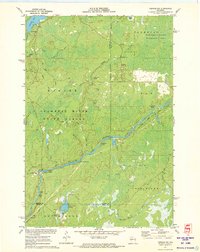
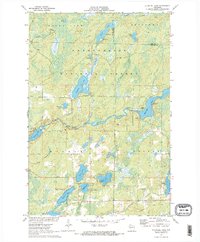
 1971 Lake Winter1973 Print · USGSSawyer County's northern forests are captured here in the early 1970s, showing a landscape defined by its rivers and emerging recreation trails. You can trace the path of the Brunet River past the Winter Lookout Tower or locate fishing spots along Lake Winter and South Barber Lake.2 unique versions available
 - 1971 Map of Ingram NW, 1973 Print
 1971 Ingram NW1973 Print · USGSSawyer County in the early 1970s is a landscape of dense forests and river networks just as modern conservation boundaries were being solidified. You can trace old logging routes like the Bissell Grade and locate historical sites such as Old Weaver Camp and Hay-Stack Corner.2 unique versions available
 - 1971 Map of Blaisdell Lake, 1973 Print
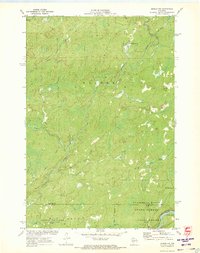
 1971 Blaisdell Lake1973 Print · USGSSawyer County’s Northwoods were a secluded network of glacial lakes and river bends in the early seventies. Genealogists and local historians can trace legacy sites like the Wa-Ha-Kee Church Camp and Glenwood Camp or the path of the regional Snowmobile Trail.2 unique versions available
 - 1972 Map of Barker Lake, 1974 Print
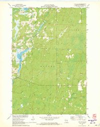
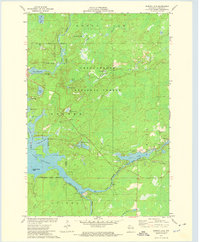 1972 Barker Lake1974 Print · USGSThe Chippewa River forks meet in Sawyer County during the early 1970s, where the national forest meets tribal lands. Trace the complex shoreline of Lake Chippewa to find Wagon Wheel Island, the Winter Dam, and isolated spots like Venison Spring.2 unique versions available
 - 1972 Map of Hogsback Creek, 1975 Print
 1972 Hogsback Creek1975 Print · USGSNorthern Wisconsin’s timber and rail history is visible in the early seventies across the Sawyer and Rusk county line. Trace legacy transport routes like the Bissell Grade and the Old Railroad Grade alongside Hogsback Creek.
 - 1972 Map of Winter, 1975 Print
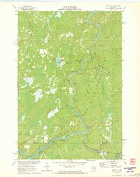
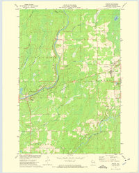 1972 Winter1975 Print · USGSSawyer County’s river valleys and timberlands are captured here in the early seventies as the rail era gave way to recreation. Genealogists and local historians can locate the Winter Cem, the small settlement of Bishop Bridge, and traces of an Old RR Grade along the Chippewa River.
End of results
Showing maps 1-10 of 10
Top cities near Winter
Top neighborhoods of Winter
Frequently asked questions
- What are the different types of historical maps available for Winter?
- What is the oldest map of Winter?
- Where can I purchase historical maps of Winter for my home or office?
- Where can I download high-res historical maps of Winter?
- Are there historical topographic maps available for Winter?
- Is there historical aerial imagery available for Winter?
- Where are historical maps of Winter sourced from?