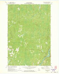
1971 Map of Babbs Island
USGS Topo · Published 1973About this map
The Flambeau River State Forest dominates this northern Wisconsin landscape, where the confluence of the Flambeau River and the South Fork Flambeau River defines the local geography. Significant watercourses like the Thornapple River and Beaver Creek wind through the township boundaries of Draper and Winter. The map documents a quiet, transitionary period in the Northwoods, where former industrial infrastructure is visible through the Old Railroad Grade cutting across the terrain.
Find a feature on this map
16 named features on this map. Tap any name to fly to it.
Don’t see what you’re looking for? This feature index may not catch every label — zoom into the map to look around manually.
Map Details
Editions of this 1971 Babbs Island Map
This is the sole edition of this map. No revisions or reprints were ever made.
Other maps of this area

1941 · Kennan
USGS Topo · 1:48,000

1941 · Kennedy
USGS Topo · 1:48,000

1944 · Draper
USGS Topo · 1:48,000

1945 · Kennedy
USGS Topo · 1:48,000

1945 · Kennan
USGS Topo · 1:48,000

1945 · Ingram
USGS Topo · 1:48,000

1947 · Ingram
USGS Topo · 1:48,000

1947 · Draper
USGS Topo · 1:48,000

1953 · Rice Lake
USGS Topo · 1:250,000

1959 · Rice Lake
USGS Topo · 1:250,000