1990s Maps of Shawano County, Wisconsin
Explore 7 historic maps of Shawano County from the 1990s. These maps offer a rare glimpse into what life looked like during the 1990s — showing old roads, neighborhoods, homes, and landmarks that have changed or disappeared over time.
Whether you're researching your family's past, planning a metal detecting trip, or studying how Shawano County's landscape evolved across the 1990s, these high-resolution maps are a powerful tool for exploring the history of this region.
- Focus on a specific era: All maps on this page are from the 1990s, giving you a focused view of this time period.
- See what’s changed: Compare century-old streets, trails, and buildings to today's modern landscape using overlays and satellite layers.
- Research with precision: Use these maps for genealogy, historical research, land use analysis, or educational projects.
- View, download, or print: Maps are fully viewable online in high resolution, and can be downloaded or printed for your own records.
Start exploring Shawano County's history through authentic maps from the 1990s. This is your window into the past.
Shawano County, WI maps
(7)- 1990 Map of Wabeno, 1991 Print
 1990 Wabeno1991 Print · USGSThe Wisconsin Northwoods in the early nineties is a landscape of deep timber, tribal lands, and glacial lakes. Researchers can trace the Chicago and North Western rail line through lumber towns like Wabeno and Townsend or locate the Lakewood State Fish Hatchery.
 - 1990 Map of Merrill, 1991 Print
 1990 Merrill1991 Print · USGSWisconsin's Northwoods transition from timber industry to recreation in the 1990s, centered on the river corridors of Lincoln and Langlade counties. Genealogists and historians can trace rail history along the Soo Line and Old RR Grade between Merrill and Antigo.
 - 1992 Map of Leeman, 1996 Print
 1992 Leeman1996 Print · USGSIn the 1990s, the Wolf River basin in Outagamie County remained a vast wetland corridor preserved through state wildlife areas. Researchers can trace rural lineages at St Lawrence Cem and Oak Hill Cem or locate the riverside hamlet of Leeman.
 - 1992 Map of Oneida North, 1996 Print
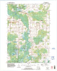
 1992 Oneida North1996 Print · USGSThe rural stretches and growing outskirts northwest of Green Bay are captured here in the early nineties as suburban expansion met long-standing farming communities. Researchers can trace local heritage through the Owego Cemetery, the institutional State Reformatory Farm, and the early footprints of Anston and Oneida.
 - 1992 Map of Nichols, 1996 Print
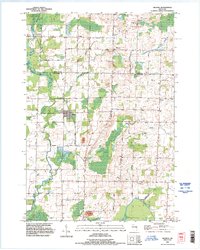 1992 Nichols1996 Print · USGSThe rural landscapes of Shawano and Outagamie counties are captured here in the early nineties, showcasing the agricultural roots of Nichols and Briarton. Local researchers can trace family landmarks like Emmanuel Cem and several small extractive sites including a Quarry and Gravel Pit.
 - 1992 Map of Seymour, 1996 Print
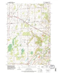
 1992 Seymour1996 Print · USGSThe agricultural lands north of Seymour are captured in the 1990s, where the rural crossroads of Isaar and Rose Lawn anchor the landscape. Genealogists can locate family sites at Elm Lawn Cem and Owego Cem while tracing the Oneida reservation boundary.
 - 1993 Map of Clintonville North, 1995 Print
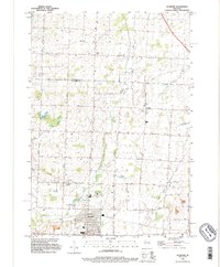
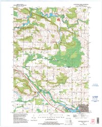 1993 Clintonville North1995 Print · USGSThe border of Shawano and Waupaca counties comes alive in the early 1990s as the river-fed landscape of Pella and Clintonville is documented. Genealogists can locate family landmarks like the St Martin Cem or trace rural routes like Magolski Road and Nietzke Road.
End of results
Showing maps 1-7 of 7
Top cities of Shawano County
- Shawano historical maps
- Belle Plaine historical maps
- Angelica historical maps
- Bonduel historical maps
- Wittenberg historical maps
- Wittenberg historical maps
See more
Frequently asked questions
- What are the different types of historical maps available for Shawano County?
- What is the oldest map of Shawano County?
- Where can I purchase historical maps of Shawano County for my home or office?
- Where can I download high-res historical maps of Shawano County?
- Are there historical topographic maps available for Shawano County?
- Is there historical aerial imagery available for Shawano County?
- Where are historical maps of Shawano County sourced from?