1960s Maps of Shawano County, Wisconsin
Explore 6 historic maps of Shawano County from the 1960s. These maps offer a rare glimpse into what life looked like during the 1960s — showing old roads, neighborhoods, homes, and landmarks that have changed or disappeared over time.
Whether you're researching your family's past, planning a metal detecting trip, or studying how Shawano County's landscape evolved across the 1960s, these high-resolution maps are a powerful tool for exploring the history of this region.
- Focus on a specific era: All maps on this page are from the 1960s, giving you a focused view of this time period.
- See what’s changed: Compare century-old streets, trails, and buildings to today's modern landscape using overlays and satellite layers.
- Research with precision: Use these maps for genealogy, historical research, land use analysis, or educational projects.
- View, download, or print: Maps are fully viewable online in high resolution, and can be downloaded or printed for your own records.
Start exploring Shawano County's history through authentic maps from the 1960s. This is your window into the past.
Shawano County, WI maps
(6)- 1964 Map of Wittenberg, 1965 Print
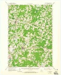 1964 Wittenberg1965 Print · USGSSettled along the border of Marathon and Shawano counties in the 1960s, this area shows a landscape shaped by timber and rail. Researchers can trace local lineage through several sites like Homme Home for Boys, St Philomena Ch, and Holy Family Cem.2 unique versions available
 - 1964 Map of Shawano, 1965 Print
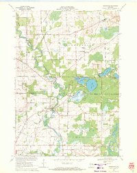
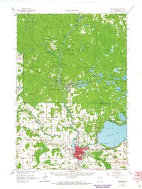 1964 Shawano1965 Print · USGSThe Menominee Indian Reservation and the growing city of Shawano are shown here in the mid-1960s as the Wolf River winds south. Genealogists and historians can trace local landmarks like the Alexian Brothers Novitiate, Keshena School, and the West Branch Cemetery.2 unique versions available
 - 1964 Map of Gresham, 1975 Print
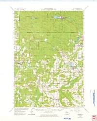 1964 Gresham1975 Print · USGSMid-century Shawano County is mapped here during a period of transition for its northern timberlands and southern farms. Genealogists and researchers can trace family names through rural landmarks like Hermanfort Sch, St Marys Cem, and Tilleda.
 - 1969 Map of Leeman, 1971 Print
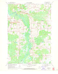 1969 Leeman1971 Print · USGSOutagamie and Shawano counties are captured here in the late sixties, where the winding Wolf River meets vast conservation lands. Researchers can locate family landmarks along Eskman Road, the St Lawrence Cem, and the old Navarino Sch.
 - 1969 Map of Embarrass, 1971 Print
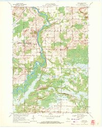
 1969 Embarrass1971 Print · USGSWisconsin's river-and-lake country comes alive in the late sixties as the Embarrass River winds past small farming communities and lakeside retreats. Trace local history at St Peter Cem, the village of Embarrass, and the shoreline developments of Adams Beach.2 unique versions available
 - 1969 Map of Lunds, 1971 Print
 1969 Lunds1971 Print · USGSWisconsin's river-fed wetlands and rural townships are captured here in the late sixties as the Wolf River snakes through the Navarino Wildlife Area. Local historians can trace family roots at Hilda Cem or locate community centers like St Wenceslaus Ch and the settlement of Lunds.
End of results
Showing maps 1-6 of 6
Top cities of Shawano County
- Shawano historical maps
- Belle Plaine historical maps
- Angelica historical maps
- Bonduel historical maps
- Wittenberg historical maps
- Wittenberg historical maps
See more
Frequently asked questions
- What are the different types of historical maps available for Shawano County?
- What is the oldest map of Shawano County?
- Where can I purchase historical maps of Shawano County for my home or office?
- Where can I download high-res historical maps of Shawano County?
- Are there historical topographic maps available for Shawano County?
- Is there historical aerial imagery available for Shawano County?
- Where are historical maps of Shawano County sourced from?