1980s Maps of Shawano County, Wisconsin
Explore 13 historic maps of Shawano County from the 1980s. These maps offer a rare glimpse into what life looked like during the 1980s — showing old roads, neighborhoods, homes, and landmarks that have changed or disappeared over time.
Whether you're researching your family's past, planning a metal detecting trip, or studying how Shawano County's landscape evolved across the 1980s, these high-resolution maps are a powerful tool for exploring the history of this region.
- Focus on a specific era: All maps on this page are from the 1980s, giving you a focused view of this time period.
- See what’s changed: Compare century-old streets, trails, and buildings to today's modern landscape using overlays and satellite layers.
- Research with precision: Use these maps for genealogy, historical research, land use analysis, or educational projects.
- View, download, or print: Maps are fully viewable online in high resolution, and can be downloaded or printed for your own records.
Start exploring Shawano County's history through authentic maps from the 1980s. This is your window into the past.
Shawano County, WI maps
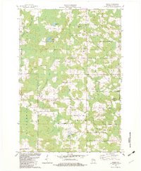
(13)- 1982 Map of Thornton
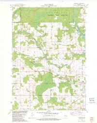 1982 Thornton1982 Print · USGSThe northern reaches of Shawano County in the early eighties show a landscape where indigenous reservation boundaries meet small railroad towns. Researchers can trace rural landmarks like St Jakobi Cem, the Soo Line tracks, and the rapids at Little Bull Falls.
 - 1982 Map of Gresham
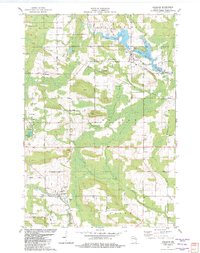 1982 Gresham1982 Print · USGSIn the early eighties, this Shawano County landscape shows the cultural intersection of the Stockbridge-Munsee Indian Reservation Boundary and rural Wisconsin life. Genealogists can trace family names at St Marys Cem and Riverview Cem or locate the old Chicago and North Western rail corridor.
 - 1982 Map of Shawano
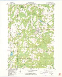
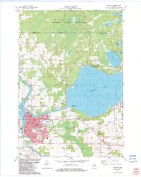 1982 Shawano1982 Print · USGSShawano and the Menominee boundary are captured here in the early eighties, showing a landscape defined by lake recreation and timber. You can trace family history at Woodlawn Cem or locate old rail landmarks along the Soo Line and Chicago and North Western.
 - 1982 Map of Neopit
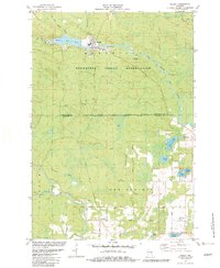 1982 Neopit1982 Print · USGSThe Menominee and Shawano county borderlands in the early 1980s showcase a landscape defined by tribal history and river systems. Genealogists can trace family landmarks like St Anthonys Cem or Red Springs Cem and locate communities at Neopit and Beaulieu.
 - 1982 Map of Wittenberg
 1982 Wittenberg1982 Print · USGSThe village of Wittenberg and surrounding timberlands are documented here in the early eighties, showing a landscape shaped by the Chicago and North Western railroad. Genealogists can trace family heritage at Holy Family Cem or investigate local landmarks like the Homme Home for Boys.
 - 1982 Map of Bowler
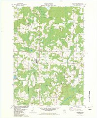
 1982 Bowler1982 Print · USGSShawano County is shown in the early 1980s as a landscape of river branches and rural settlements. Genealogists and local historians can trace family-named routes like Logemann Lane and locate community anchors such as Peace Cem and Bethany Ch.
 - 1982 Map of Birnamwood
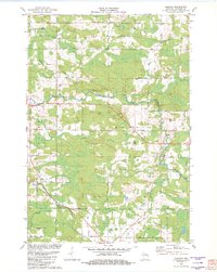
 1982 Birnamwood1982 Print · USGSThe village of Birnamwood and its railroad connections are documented here in the early eighties. Genealogists can locate family sites at St Philomena Cem, Forest Cem, and St Johns Ch Cem along the Embarrass River valley.
 - 1982 Map of Shepley
 1982 Shepley1982 Print · USGSShawano County's rural townships are documented here in the early 1980s, showcasing the winding Middle Branch Embarrass River and local rail stops. Genealogists can trace family footprints near Shepley, Whitcomb, and Immanuel Ch.
 - 1982 Map of Regina
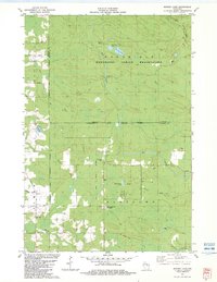
 1982 Regina1982 Print · USGSShawano County's river valleys and timberlands are captured here during the early eighties, showing a landscape shaped by the North Branch Embarrass River. You can trace old transit lines like the Old Railroad Grade or locate family sites at Regina, Five Corners, and Riverside Cem.
 - 1982 Map of Burney Lake, 1983 Print
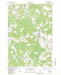
 1982 Burney Lake1983 Print · USGSTribal lands and river systems define this Shawano County landscape during the early eighties. Researchers can trace the Old Railroad Grade and locate local landmarks like the Stockbridge-Munsee Indian Agency and Wilderness Ch.
 - 1982 Map of Keshena, 1983 Print
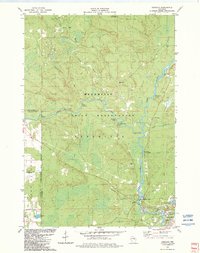 1982 Keshena1983 Print · USGSThe Menominee Indian Reservation in the early eighties was a landscape of powerful river systems and established community sites. Genealogists and historians can locate Keshena landmarks like St Michaels Ch and St Josephs Sch, or trace the many rapids and falls along the Wolf River.
 - 1984 Map of Shawano, 1985 Print
 1984 Shawano1985 Print · USGSNortheast Wisconsin in the mid-1980s was a landscape defined by its indigenous heritage and the bustling trade centers of the Fox and Wolf River valleys. Genealogists and historians can trace rail corridors like the Chicago and North Western or locate family sites near Keshena, Cecil, and the Fort Howard Cem.2 unique versions available
 - 1984 Map of Wausau, 1990 Print
 1984 Wausau1990 Print · USGSMarathon and Portage counties come into focus during the mid-eighties as industrial river towns and sprawling conservation areas define the Central Wisconsin landscape. Researchers can trace the rail corridors of the Soo Line or locate rural landmarks like Rib Mountain State Park and St Marys Cem.
End of results
Showing maps 1-13 of 13
Top cities of Shawano County
- Shawano historical maps
- Belle Plaine historical maps
- Angelica historical maps
- Bonduel historical maps
- Wittenberg historical maps
- Wittenberg historical maps
See more
Frequently asked questions
- What are the different types of historical maps available for Shawano County?
- What is the oldest map of Shawano County?
- Where can I purchase historical maps of Shawano County for my home or office?
- Where can I download high-res historical maps of Shawano County?
- Are there historical topographic maps available for Shawano County?
- Is there historical aerial imagery available for Shawano County?
- Where are historical maps of Shawano County sourced from?