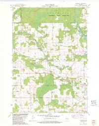
1982 Map of Thornton
USGS Topo · Published 1982About this map
The Menominee Indian Reservation and the Stockbridge-Munsee Indian Reservation Boundary anchor the northern landscape of this 1982 map. The terrain is defined by the winding course of the Red River and Wolf River, where several distinctive cataracts such as Freeman Falls, Gilmer Falls, and Little Bull Falls highlight the river's descent. The map reveals a rural community structured around local landmarks and faith, including St Jakobi Ch and Salem Ch, each with its corresponding cemetery. Transport and industry in the area are represented by the crossing lines of the Chicago and North Western and Soo Line railroads, which intersect near the small settlement of Thornton. This detailed view from the early 1980s preserves the spatial relationship between the indigenous reservation lands and the surrounding agricultural townships of Richmond and Belle Plaine.
Find a feature on this map
51 named features on this map. Tap any name to fly to it.
Don’t see what you’re looking for? This feature index may not catch every label — zoom into the map to look around manually.
Map Details
Editions of this 1982 Thornton Map
This is the sole edition of this map. No revisions or reprints were ever made.
Other maps of this area

1954 · Gresham
USGS Topo · 1:48,000

1954 · Shawano
USGS Topo · 1:48,000

1955 · Embarrass
USGS Topo · 1:48,000

1955 · Clintonville
USGS Topo · 1:48,000

1955 · Green Bay
USGS Topo · 1:250,000

1964 · Shawano
USGS Topo · 1:62,500

1964 · Gresham
USGS Topo · 1:62,500

1969 · Embarrass
USGS Topo · 1:24,000

1969 · Lunds
USGS Topo · 1:24,000

1970 · Clintonville North
USGS Topo · 1:24,000