1970s Maps of Russell, Wisconsin
Explore 4 historic maps of Russell from the 1970s. These maps offer a rare glimpse into what life looked like during the 1970s — showing old roads, neighborhoods, homes, and landmarks that have changed or disappeared over time.
Whether you're researching your family's past, planning a metal detecting trip, or studying how Russell's landscape evolved across the 1970s, these high-resolution maps are a powerful tool for exploring the history of this region.
- Focus on a specific era: All maps on this page are from the 1970s, giving you a focused view of this time period.
- See what’s changed: Compare century-old streets, trails, and buildings to today's modern landscape using overlays and satellite layers.
- Research with precision: Use these maps for genealogy, historical research, land use analysis, or educational projects.
- View, download, or print: Maps are fully viewable online in high resolution, and can be downloaded or printed for your own records.
Start exploring Russell's history through authentic maps from the 1970s. This is your window into the past.
Russell, WI maps
(4)- 1974 Map of St. Cloud, 1977 Print
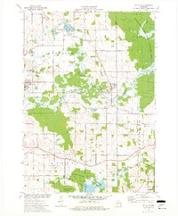 1974 St. Cloud1977 Print · USGSFond du Lac and Sheboygan counties are captured in the mid-seventies, showing a landscape defined by conservation and glacial water. Genealogists can locate family landmarks like Forest Home Cem, St Joseph Ch, and the historic St Lawrence Seminary.
 - 1974 Map of Kiel, 1977 Print
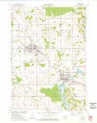 1974 Kiel1977 Print · USGSThe manufacturing corridor between Kiel and New Holstein comes into focus in the mid-seventies, highlighting a landscape shaped by rail and river. Genealogists and local historians can trace family-named roads and landmarks like Holy Rosary Cem, the SS Peter and Paul Cem, and the old Kilns.
 - 1974 Map of Elkhart Lake, 1977 Print
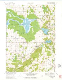 1974 Elkhart Lake1977 Print · USGSElkhart Lake and the surrounding kettle moraine country are captured here in the mid-seventies, showing a landscape defined by glacial hydrology and historic preservation. Trace the old road network around Glenbeulah and locate landmarks like the Old Wade House State Park or the Road America Raceway.
 - 1974 Map of Marytown, 1977 Print
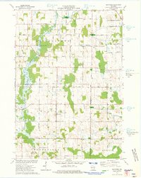 1974 Marytown1977 Print · USGSEastern Wisconsin dairy country is captured here in the mid-seventies at the meeting of Calumet, Fond du Lac, and Sheboygan counties. Genealogists can trace family farm locations near Marytown, Charlesburg, and the St Charles Cem.
End of results
Showing maps 1-4 of 4
Top cities near Russell
- Plymouth historical maps
- Taycheedah historical maps
- Chilton historical maps
- New Holstein historical maps
- Kiel historical maps
- Greenbush historical maps
See more
Frequently asked questions
- What are the different types of historical maps available for Russell?
- What is the oldest map of Russell?
- Where can I purchase historical maps of Russell for my home or office?
- Where can I download high-res historical maps of Russell?
- Are there historical topographic maps available for Russell?
- Is there historical aerial imagery available for Russell?
- Where are historical maps of Russell sourced from?