1940s Maps of Walworth County, Wisconsin
Explore 2 historic maps of Walworth County from the 1940s. These maps offer a rare glimpse into what life looked like during the 1940s — showing old roads, neighborhoods, homes, and landmarks that have changed or disappeared over time.
Whether you're researching your family's past, planning a metal detecting trip, or studying how Walworth County's landscape evolved across the 1940s, these high-resolution maps are a powerful tool for exploring the history of this region.
- Focus on a specific era: All maps on this page are from the 1940s, giving you a focused view of this time period.
- See what’s changed: Compare century-old streets, trails, and buildings to today's modern landscape using overlays and satellite layers.
- Research with precision: Use these maps for genealogy, historical research, land use analysis, or educational projects.
- View, download, or print: Maps are fully viewable online in high resolution, and can be downloaded or printed for your own records.
Start exploring Walworth County's history through authentic maps from the 1940s. This is your window into the past.
Walworth County, WI maps
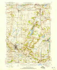
(2)- 1944 Map of Belvidere
 1944 Belvidere1944 Print · USGSNorthern Illinois at the height of the Second World War shows a landscape defined by rail-fed farming villages and dozens of country schoolhouses. Genealogists can trace family footprints near Scotch Church, the Fairgrounds, and settlements like Poplar Grove.2 unique versions available
 - 1944 Map of McHenry, 1958 Print
 1944 McHenry1958 Print · USGSMcHenry County at the end of the war era reveals a dense network of rural schoolhouses and established railroad towns. Genealogists can trace family footprints near Solon Mills, Terra Cotta, and dozens of district schools like Queen Anne School.2 unique versions available
End of results
Showing maps 1-2 of 2
Top cities of Walworth County
- Elkhorn historical maps
- Delavan historical maps
- Lake Geneva historical maps
- East Troy historical maps
- Lyons historical maps
- Genoa City historical maps
See more
Frequently asked questions
- What are the different types of historical maps available for Walworth County?
- What is the oldest map of Walworth County?
- Where can I purchase historical maps of Walworth County for my home or office?
- Where can I download high-res historical maps of Walworth County?
- Are there historical topographic maps available for Walworth County?
- Is there historical aerial imagery available for Walworth County?
- Where are historical maps of Walworth County sourced from?