1990s Maps of Walworth County, Wisconsin
Explore 2 historic maps of Walworth County from the 1990s. These maps offer a rare glimpse into what life looked like during the 1990s — showing old roads, neighborhoods, homes, and landmarks that have changed or disappeared over time.
Whether you're researching your family's past, planning a metal detecting trip, or studying how Walworth County's landscape evolved across the 1990s, these high-resolution maps are a powerful tool for exploring the history of this region.
- Focus on a specific era: All maps on this page are from the 1990s, giving you a focused view of this time period.
- See what’s changed: Compare century-old streets, trails, and buildings to today's modern landscape using overlays and satellite layers.
- Research with precision: Use these maps for genealogy, historical research, land use analysis, or educational projects.
- View, download, or print: Maps are fully viewable online in high resolution, and can be downloaded or printed for your own records.
Start exploring Walworth County's history through authentic maps from the 1990s. This is your window into the past.
Walworth County, WI maps
(2)- 1992 Map of Hebron
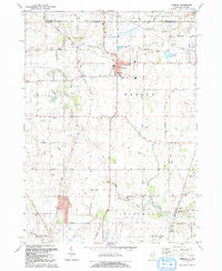 1992 Hebron1992 Print · USGSHebron and the surrounding farmland of McHenry County are shown here in the early 1990s, just as the region maintained its rural character against the state border. Researchers can trace family history at Linn-Hebron Cem or locate the old Old Railroad Grade and Galt Airport.2 unique versions available
 - 1992 Map of Richmond
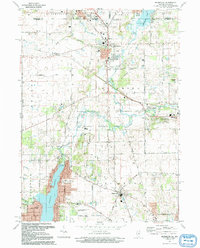 1992 Richmond1992 Print · USGSThe Illinois-Wisconsin borderlands come alive in the early nineties, showing the transition from rural crossroads to growing communities. Genealogists and historians can trace family sites like Washington Cem and schools in Richmond or Ringwood.
End of results
Showing maps 1-2 of 2
Top cities of Walworth County
- Elkhorn historical maps
- Delavan historical maps
- Lake Geneva historical maps
- East Troy historical maps
- Lyons historical maps
- Genoa City historical maps
See more
Frequently asked questions
- What are the different types of historical maps available for Walworth County?
- What is the oldest map of Walworth County?
- Where can I purchase historical maps of Walworth County for my home or office?
- Where can I download high-res historical maps of Walworth County?
- Are there historical topographic maps available for Walworth County?
- Is there historical aerial imagery available for Walworth County?
- Where are historical maps of Walworth County sourced from?