Old Maps of Walworth County, Wisconsin for Metal Detecting
Plan your next treasure hunt with 96 historic maps of Walworth County. Find old homesites, ghost towns, trails, and gathering spots that may be lost to time — perfect for identifying promising metal detecting locations.
- Locate forgotten sites: Uncover places like long-lost settlements, abandoned rail lines, or gathering spots.
- Plan better hunts: Use map overlays combined with LiDAR or satellite views to narrow in on historically rich areas.
- Made for detectorists: Thousands of hobbyists use these maps to discover relics, coins, and hidden history.
Use these historic maps to boost your research and find new opportunities beneath the surface of Walworth County.
Walworth County, WI maps
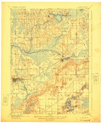
(96)- 1891 Map of Koshkonong
 1891 Koshkonong1891 Print · USGSJefferson County was an evolving hub of river power and rail transit in the 1890s. Researchers can trace the early footprints of Jefferson and Fort Atkinson or locate rural landmarks like Busseyville and Cold Spring.
 - 1892 Map of Whitewater
 1892 Whitewater1892 Print · USGSSoutheastern Wisconsin's glaciated landscape is revealed in the late nineteenth century as the rail network began to shape local growth. Trace the path of the Chicago Milwaukee And St. Paul Railroad through Whitewater, Palmyra, and the marshes of the Bark River.
 - 1892 Map of Eagle
 1892 Eagle1892 Print · USGSSoutheast Wisconsin's glaciated landscape is captured here in the late nineteenth century as new rail lines transformed the frontier into a network of dairy and mill towns. Genealogists can trace early homesteads and rail stops like Genesee Depot, Caldwell Prairie, and Eagleville near the shores of Phantom Lake.
 - 1893 Map of Delavan
 1893 Delavan1893 Print · USGSWalworth County at the close of the nineteenth century reveals a landscape of growing lakefront communities and vital rail junctions. Genealogists and historians can trace the early footprints of Delavan, Elkhorn, and Sharon, alongside lakeside landmarks like Williams Bay and Fontana.6 unique versions available
 - 1893 Map of Whitewater
 1893 Whitewater1893 Print · USGSThe dairy lands and glacial lake districts of southeastern Wisconsin are captured here in the late nineteenth century. Trace the early village footprints of Whitewater and Palmyra, or follow the iron path of the Prairie Du Chien Division Railroad past Lauderdale Lakes.7 unique versions available
 - 1893 Map of Shopiere
 1893 Shopiere1893 Print · USGSRock County's rural landscape is captured here in the 1890s, when steam rail dominated the local economy and travel. Genealogists and researchers can trace the early footprints of Clinton Junction, the winding path of Turtle Creek, and small rural centers like Emerald Grove.5 unique versions available
 - 1893 Map of Geneva
 1893 Geneva1893 Print · USGSSoutheastern Wisconsin thrived as a rail and lakeside hub in the 1890s. Genealogists and historians can trace old homesteads near Geneva, Slades Corners, and Springfield, or follow the routes of the Wisconsin Central Railroad.2 unique versions available
 - 1894 Map of Eagle
 1894 Eagle1894 Print · USGSSoutheast Wisconsin in the late nineteenth century was defined by a thriving rail network and glacial lake landscapes. Researchers can trace the early footprints of settlements like Genesee and East Troy alongside the Fox River and the Wisconsin Central Railroad.
 - 1894 Map of Koshkonong
 1894 Koshkonong1894 Print · USGSSouthern Wisconsin at the end of the nineteenth century is defined by its glacial lakes and expanding rail networks. Genealogists can trace family footprints in Fort Atkinson and Milton Junction, or locate small settlements like Busseyville and Cold Spring.2 unique versions available
 - 1897 Map of Eagle
 1897 Eagle1897 Print · USGSSoutheast Wisconsin in the late nineteenth century was a landscape of thriving rail-side villages and interconnected kettle lakes. Genealogists and researchers can trace early homesteads and rail stops like Genesee Depot, North Prairie, and the bustling lakefront at Mukwonago.
 - 1903 Map of Whitewater
 1903 Whitewater1903 Print · USGSSoutheastern Wisconsin at the turn of the century reveals a landscape of thriving rail towns and glacial lake systems. Trace the early routes of the Chicago Milwaukee and St Paul railroad between Whitewater and Palmyra, or locate old lakeside settlements like Heart Prairie.5 unique versions available
 - 1904 Map of Lake Geneva, 1955 Print
 1904 Lake Geneva1955 Print · USGSSoutheast Wisconsin at the turn of the century shows a landscape defined by its great lakes and a dense network of competing rail lines. Genealogists and local historians can trace the early village footprints of Burlington, Genoa Junction, and Spring Prairie along the White River.
 - 1906 Map of Eagle
 1906 Eagle1906 Print · USGSSoutheastern Wisconsin's glaciated terrain is remarkably detailed in this early century survey of the Fox River valley. Genealogists and local historians can trace the early rail-stop settlements of Genesee Depot, North Prairie, and Eagleville alongside landmarks like Lake Beulah and Honey Creek.6 unique versions available
 - 1906 Map of Koshkonong
 1906 Koshkonong1906 Print · USGSSouthern Wisconsin at the turn of the century was a landscape of expanding rail junctions and river towns. Trace the early footprints of Fort Atkinson and Jefferson, or follow the rail lines connecting Milton Junction and Lima Center.3 unique versions available
 - 1906 Map of Lake Geneva
 1906 Lake Geneva1906 Print · USGSSoutheastern Wisconsin's glacial landscape is fully developed as a premier resort and rail hub in the early 1900s. Researchers can trace the early grids of Lake Geneva and Burlington or locate old rail stops at Genoa Junction and Springfield.4 unique versions available
 - 1918 Map of Belvidere
 1918 Belvidere1918 Print · USGSBoone County and the Kishwaukee River valley are captured here in the final year of the Great War. Researchers can trace dozens of rural school sites like Quailtrap School or locate family roots near Argyle and the Scotch Cemetery.
 - 1924 Map of Whitewater
 1924 Whitewater1924 Print · USGSSoutheastern Wisconsin at the turn of the century shows a landscape of glacial lakes and thriving rail-side towns. Genealogists and historians can trace old homesteads near Heaths Mills, the station at Palmyra, and the early township centers of Rome and Lagrange.4 unique versions available
 - 1926 Map of Mc Henry
 1926 Mc Henry1926 Print · USGSMcHenry County in the mid-twenties is a landscape of thriving rural school districts and busy rail junctions. Genealogists can locate family-named landmarks like McConnell School and Burgett School or trace the early paths of the Chicago Milwaukee and St. Paul railroad.3 unique versions available
 - 1932 Map of Harvard
 1932 Harvard1932 Print · USGSNorthern Illinois and the Wisconsin borderlands are captured here in the early 1930s, centered on the rail hub of Harvard. Genealogists can locate dozens of named rural schools like Hoppen School and Shields School, or trace the path of the Chicago and Northwestern Electric (Abandoned) line.3 unique versions available
 - 1937 Map of Harvard
 1937 Harvard1937 Print · USGSUpper Illinois and the Wisconsin borderlands are shown here in the mid-1930s, centered on the bustling rail junction at Harvard. Genealogists can trace family footprints across dozens of country schoolhouse sites like White Oak Sch and the rural cemeteries of Dunham township.2 unique versions available
 - 1944 Map of Belvidere
 1944 Belvidere1944 Print · USGSNorthern Illinois at the height of the Second World War shows a landscape defined by rail-fed farming villages and dozens of country schoolhouses. Genealogists can trace family footprints near Scotch Church, the Fairgrounds, and settlements like Poplar Grove.2 unique versions available
 - 1944 Map of McHenry, 1958 Print
 1944 McHenry1958 Print · USGSMcHenry County at the end of the war era reveals a dense network of rural schoolhouses and established railroad towns. Genealogists can trace family footprints near Solon Mills, Terra Cotta, and dozens of district schools like Queen Anne School.2 unique versions available
 - 1954 Map of Rockford
 1954 Rockford1954 Print · USGSThe Rock River valley and the Illinois-Wisconsin borderlands are captured here in the mid-1950s during a period of robust industrial and agricultural activity. Genealogists and historians can trace rail-era corridors like the Illinois Central RR and locate landmarks from Big Foot Prairie to Lake Geneva.
 - 1955 Map of Rockford
 1955 Rockford1955 Print · USGSThe Rock River valley and southern Wisconsin dairy country are shown here in the mid-fifties as the region's manufacturing centers grew. Genealogists and historians can trace the paths of the Chicago and North Western RR and Illinois Central RR through hubs like Rockford and Beloit.
 - 1958 Map of Rockford, 1974 Print
 1958 Rockford1974 Print · USGSNorthern Illinois and southern Wisconsin are shown here in the mid-twentieth century as rail-dependent industrial towns began to interface with growing lakefront communities. Genealogists can trace family roots through settlements like Saylesville and Tess Corners or locate historical landmarks like the Rockford Ordnance Depot.4 unique versions available
Showing maps 1-25 of 96
Top cities of Walworth County
- Elkhorn historical maps
- Delavan historical maps
- Lake Geneva historical maps
- East Troy historical maps
- Lyons historical maps
- Genoa City historical maps
See more
Frequently asked questions
- What are the different types of historical maps available for Walworth County?
- What is the oldest map of Walworth County?
- Where can I purchase historical maps of Walworth County for my home or office?
- Where can I download high-res historical maps of Walworth County?
- Are there historical topographic maps available for Walworth County?
- Is there historical aerial imagery available for Walworth County?
- Where are historical maps of Walworth County sourced from?