1940s Maps of Washburn County, Wisconsin
Explore 10 historic maps of Washburn County from the 1940s. These maps offer a rare glimpse into what life looked like during the 1940s — showing old roads, neighborhoods, homes, and landmarks that have changed or disappeared over time.
Whether you're researching your family's past, planning a metal detecting trip, or studying how Washburn County's landscape evolved across the 1940s, these high-resolution maps are a powerful tool for exploring the history of this region.
- Focus on a specific era: All maps on this page are from the 1940s, giving you a focused view of this time period.
- See what’s changed: Compare century-old streets, trails, and buildings to today's modern landscape using overlays and satellite layers.
- Research with precision: Use these maps for genealogy, historical research, land use analysis, or educational projects.
- View, download, or print: Maps are fully viewable online in high resolution, and can be downloaded or printed for your own records.
Start exploring Washburn County's history through authentic maps from the 1940s. This is your window into the past.
Washburn County, WI maps
(10)- 1947 Map of Chittamo, 1956 Print
 1947 Chittamo1956 Print · USGSNorthwest Wisconsin's lake country is captured in the mid-1940s, showing a land of dense wetlands and winding river systems. Genealogists and historians can locate rural schoolhouses like Chittamo Sch and trace the original paths of the Totagatic River and Claire River.2 unique versions available
 - 1947 Map of Minong, 1964 Print
 1947 Minong1964 Print · USGSNorthwest Wisconsin's lake country is captured here in the late 1940s as rail and road corridors began to open the woods for more permanent settlement. Genealogists can locate family-named landmarks and rural hubs like Wascott Ch, Hoover Sch, and the village of Minong.
 - 1948 Map of Spooner, 1955 Print
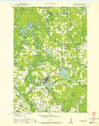 1948 Spooner1955 Print · USGSWashburn County in the late 1940s was a landscape of Northwoods river valleys and emerging railroad towns. You can trace the rural network of schools and cemeteries, from Anah Cemetery to Julia Sch, or follow the Chicago and North Western tracks.
 - 1948 Map of Stone Lake, 1958 Print
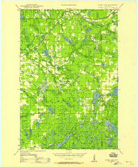 1948 Stone Lake1958 Print · USGSWashburn and Sawyer counties are captured here in the late 1940s, showing a landscape defined by glacial lakes and intersecting railroads. Researchers can trace rural school locations like Edgewood Sch, the Evergreen Cem, and landmarks like the Potato Lake Fire Tower.2 unique versions available
 - 1949 Map of Chittamo
 1949 Chittamo1949 Print · USGSNorthwestern Wisconsin at the end of the 1940s shows a landscape of scattered settlements and winding rivers before modern development. Genealogists and historians can trace family locations near Chittamo Sch, Stanberry, and the Totagatic Dam.
 - 1949 Map of Hertel
 1949 Hertel1949 Print · USGSThe lakeside communities and rural school districts of northern Wisconsin are frozen in time here in the late forties. Researchers can trace family roots through numerous local sites like Sacred Heart Ch, Hertel, and the Bashaw Brook School.
 - 1949 Map of Minong
 1949 Minong1949 Print · USGSNorthwestern Wisconsin’s lake country is captured here in the late 1940s, when the North Western railroad still linked small timber and rail towns. Researchers can locate vanished landmarks like Hoover Sch, Wascott Ch, and the small settlement of Lakeside.
 - 1949 Map of Webb Lake
 1949 Webb Lake1949 Print · USGSNorthwest Wisconsin’s lake country is captured here in the late 1940s as rural life centered on the St Croix River. Researchers can trace old crossroads and remote outposts like Dairyland, Cozy Corners, and the historic Webb Lake Sch.
 - 1949 Map of Spooner
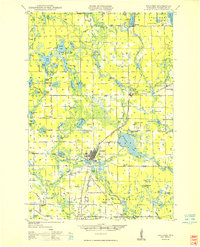 1949 Spooner1949 Print · USGSWashburn County in the late 1940s reveals a transition from a rail-dependent frontier to a motorized agricultural and recreational region. Genealogists and historians can locate dozens of country schools like Tadpole Sch and burial grounds such as Anah Cemetery.
 - 1949 Map of Rice Lake, 1961 Print
 1949 Rice Lake1961 Print · USGSIn the Wisconsin Northwoods after the war, the lakeside communities and rural schools of Barron and Washburn counties remained tightly knit. Genealogists can find family landmarks like Loveland Corners, Evergreen Ch, and the many rural schools including Lincoln Sch.
End of results
Showing maps 1-10 of 10
Top cities of Washburn County
- Spooner historical maps
- Shell Lake historical maps
- Trego historical maps
- Beaver Brook historical maps
- Minong historical maps
- Springbrook historical maps
See more
Frequently asked questions
- What are the different types of historical maps available for Washburn County?
- What is the oldest map of Washburn County?
- Where can I purchase historical maps of Washburn County for my home or office?
- Where can I download high-res historical maps of Washburn County?
- Are there historical topographic maps available for Washburn County?
- Is there historical aerial imagery available for Washburn County?
- Where are historical maps of Washburn County sourced from?