1980s Maps of Washburn County, Wisconsin
Explore 21 historic maps of Washburn County from the 1980s. These maps offer a rare glimpse into what life looked like during the 1980s — showing old roads, neighborhoods, homes, and landmarks that have changed or disappeared over time.
Whether you're researching your family's past, planning a metal detecting trip, or studying how Washburn County's landscape evolved across the 1980s, these high-resolution maps are a powerful tool for exploring the history of this region.
- Focus on a specific era: All maps on this page are from the 1980s, giving you a focused view of this time period.
- See what’s changed: Compare century-old streets, trails, and buildings to today's modern landscape using overlays and satellite layers.
- Research with precision: Use these maps for genealogy, historical research, land use analysis, or educational projects.
- View, download, or print: Maps are fully viewable online in high resolution, and can be downloaded or printed for your own records.
Start exploring Washburn County's history through authentic maps from the 1980s. This is your window into the past.
Washburn County, WI maps
(21)- 1980 Map of Sandstone
 1980 Sandstone1980 Print · USGSPine County and the Minnesota-Wisconsin borderlands are shown here in the early eighties as a region of dense state forests and river corridors. Genealogists and historians can trace rail-town development along the Burlington Northern including Sandstone, Askov, and Hinckley.
 - 1980 Map of Spooner
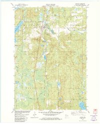
 1980 Spooner1980 Print · USGSNorthwestern Wisconsin at the dawn of the eighties reveals a landscape of deep forests and transitioning rail corridors. Genealogists and historians can trace lakefront settlements like Spooner and Birchwood or follow the early Tuscobia-Park Falls State Trail.
 - 1980 Map of Solon Springs
 1980 Solon Springs1980 Print · USGSNorthern Wisconsin in the early eighties was a landscape of dense timber and sprawling glacial waters. Trace the legacy of the Chicago and North Western rail line through Solon Springs, Hayward, and Minong at this pivotal moment.
 - 1981 Map of Sarona, 1982 Print
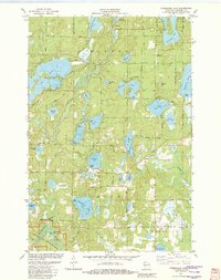
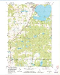
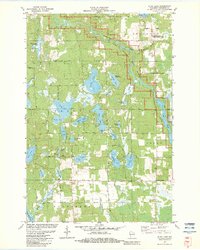
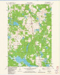 1981 Sarona1982 Print · USGSWashburn County's lake-rich timberlands are documented here in the early 1980s, centered on the rail village of Sarona. Researchers can trace old family roads and landmarks like Shelton Lookout Tower, the Sarona Cem, and the Landing Strip.2 unique versions available
 - 1982 Map of Birchwood
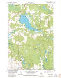
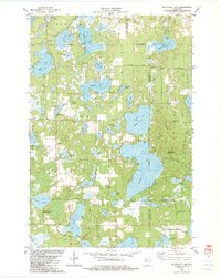
 1982 Birchwood1982 Print · USGSThe village of Birchwood stands at a three-county junction in the early 1980s, surrounded by a labyrinth of glacial lakes. Researchers can trace local landmarks like Woodlawn Cem, the Tuscobia Parkway State Trail, and Stouts Point on Red Cedar Lake.
 - 1982 Map of Minong
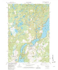
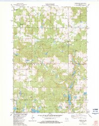
 1982 Minong1982 Print · USGSWashburn County in the early eighties is a landscape of glacial lakes and rail-line villages. Researchers can trace the Chicago and North Western railroad through Minong, locating Greenwood Cem and the settlement at Stuntz.
 - 1982 Map of Spooner Lake
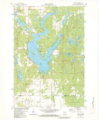
 1982 Spooner Lake1982 Print · USGSWashburn County's lake-dotted landscape is captured in the early eighties, showing a region defined by its conservation areas and northern rail corridors. Trace local landmarks like the Anah Ch settlement and the University of Wisconsin Experimental Farm along the Yellow River.
 - 1982 Map of Horseshoe Lake
 1982 Horseshoe Lake1982 Print · USGSWashburn County's lake country is captured here in the early eighties, showing a landscape defined by the Namekagon River and numerous glacial basins. Genealogists and local historians can trace small landings and community sites like Menah, Byrkits Landing, and the Sutherland Landing Strip.
 - 1982 Map of Nobleton
 1982 Nobleton1982 Print · USGSWashburn and Barron counties are shown in the early eighties during a peak era of lakeside recreation and rural settlement. Researchers can trace family sites near Nobleton, the Tomahawk Scout Reservation, and the Long Lake Cem.
 - 1982 Map of Gordon
 1982 Gordon1982 Print · USGSDouglas and Washburn counties are depicted in the early 1980s as the regional rail-and-river network supported both the timber industry and growing recreational use. Researchers can locate the Wascott Cem, trace the Chicago and North Western line through Wascott, and explore the many glacial basins like Bardon Lake.
 - 1982 Map of Trego
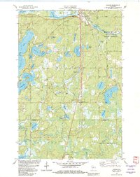
 1982 Trego1982 Print · USGSWashburn County in the early eighties centers on the river-and-rail corridor where the Namekagon River meets the Trego settlement. Genealogists and local researchers can locate the Lampson Cem, the Wesleyan Ch, and numerous family-named springs.
 - 1982 Map of Shell Lake
 1982 Shell Lake1982 Print · USGSThe Northwoods shoreline of Shell Lake is shown in detail during the early eighties, alongside the southern village of Barronett. Trace local history through the Chicago and North Western rail line and sites like Lakeside Cem and Memorial Park.
 - 1982 Map of Timberland, 1983 Print
 1982 Timberland1983 Print · USGSThe area surrounding Timberland in the early eighties is a landscape of glacial lakes and river forks. Genealogists and local historians can trace the rural communities at Timberland Cem, South Dewey Community Ch, and the Lookout Tower.
 - 1982 Map of Spooner, 1983 Print
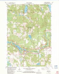
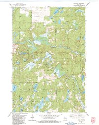
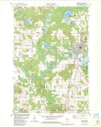 1982 Spooner1983 Print · USGSSpooner and the surrounding Washburn County wetlands are shown here in the early eighties as a thriving rail and agricultural center. Researchers can trace the Chicago and North Western rail lines through Chicago Junction and locate the Rocky Ridge Cem or State Fish Hatchery.
 - 1982 Map of Poquettes Lake, 1983 Print
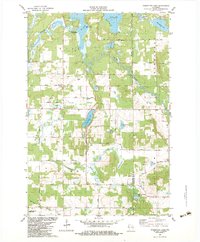 1982 Poquettes Lake1983 Print · USGSThe lake-dotted timberlands of Northwest Wisconsin are captured here in the early eighties, showcasing a rural landscape shaped by the Yellow River. Researchers can trace old family names and sites through local landmarks like Greendale Cem, Bashaw Trout Springs, and the St Croix Indian Reservation.
 - 1982 Map of Minong Flowage, 1983 Print
 1982 Minong Flowage1983 Print · USGSWisconsin's north woods and the sprawling Minong Flowage are captured here in the early eighties. Outdoor enthusiasts and local historians can trace the paths of Hang Road, find the State Youth Camp, and locate numerous public lake access points.
 - 1982 Map of Dunn Lake, 1983 Print
 1982 Dunn Lake1983 Print · USGSNorthwestern Wisconsin’s glaciated lake country is captured here in the early 1980s, centered on the wild Namekagon River. Researchers can locate family landmarks like Rosewood Cem or trace the rural character of Tadpole Corners and Trego Lake.
 - 1982 Map of Mc Kenzie Lake, 1983 Print
 1982 Mc Kenzie Lake1983 Print · USGSThe lake country of northwest Wisconsin comes alive in the early eighties, showcasing a landscape of dense woods and glacial basins. Genealogists and local historians can locate the Sacred Hearts Cem, the McKenzie Lake Lookout Tower, and the St Croix Indian Reservation.
 - 1983 Map of Frog Lake
 1983 Frog Lake1983 Print · USGSThe Burnett and Washburn county borderlands are shown here in the early eighties as a dense maze of glacial lakes and riverways. You can trace early township landmarks like Forest Home Cem, the Fivemile Lookout Tower, and crossings at McDowell Bridge.
 - 1983 Map of Scovils Lake
 1983 Scovils Lake1983 Print · USGSThe St. Croix River corridor in the early 1980s reveals a landscape of protected riverways and quiet Northwoods settlements. Researchers can trace historic access points like Coppermine Dam or locate the Riverhill Cem and the former route of the Old RR Grade Road.
 - 1985 Map of Grantsburg
 1985 Grantsburg1985 Print · USGSThe river borderlands of Minnesota and Wisconsin come alive in the mid-1980s, showcasing the intricate water networks and forest preserves of Burnett and Pine counties. Trace the rail lines of the Soo Line or find rural landmarks like Trade Lake Ch and Hildas Corner.2 unique versions available
End of results
Showing maps 1-21 of 21
Top cities of Washburn County
- Spooner historical maps
- Shell Lake historical maps
- Trego historical maps
- Beaver Brook historical maps
- Minong historical maps
- Springbrook historical maps
See more
Frequently asked questions
- What are the different types of historical maps available for Washburn County?
- What is the oldest map of Washburn County?
- Where can I purchase historical maps of Washburn County for my home or office?
- Where can I download high-res historical maps of Washburn County?
- Are there historical topographic maps available for Washburn County?
- Is there historical aerial imagery available for Washburn County?
- Where are historical maps of Washburn County sourced from?