1950s Maps of Washburn County, Wisconsin
Explore 16 historic maps of Washburn County from the 1950s. These maps offer a rare glimpse into what life looked like during the 1950s — showing old roads, neighborhoods, homes, and landmarks that have changed or disappeared over time.
Whether you're researching your family's past, planning a metal detecting trip, or studying how Washburn County's landscape evolved across the 1950s, these high-resolution maps are a powerful tool for exploring the history of this region.
- Focus on a specific era: All maps on this page are from the 1950s, giving you a focused view of this time period.
- See what’s changed: Compare century-old streets, trails, and buildings to today's modern landscape using overlays and satellite layers.
- Research with precision: Use these maps for genealogy, historical research, land use analysis, or educational projects.
- View, download, or print: Maps are fully viewable online in high resolution, and can be downloaded or printed for your own records.
Start exploring Washburn County's history through authentic maps from the 1950s. This is your window into the past.
Washburn County, WI maps
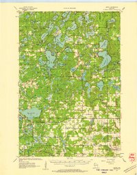
(16)- 1950 Map of Stone Lake
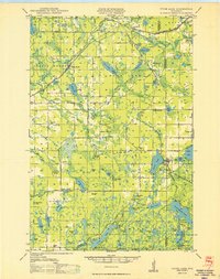 1950 Stone Lake1950 Print · USGSWashburn and Sawyer Counties are shown in the 1950s at the height of their rural rail and schoolhouse era. Researchers can trace the legacy of small communities through the Evergreen Cem, the Potato Lake Fire Tower, and local landmarks like Stinnett Sch and Mackay Valley Sch.
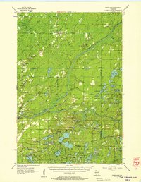
 - 1951 Map of Cumberland
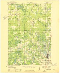 1951 Cumberland1951 Print · USGSCumberland and the surrounding lake country appear in the early fifties as a landscape of rural schoolhouses and small farming hamlets. Researchers can trace the locations of Roosevelt Sch, Loraine, and the lakeside settlement of Timberland.
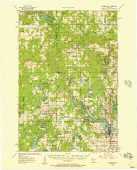
 - 1951 Map of Shell Lake
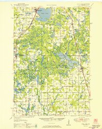 1951 Shell Lake1951 Print · USGSWisconsin's lakeland region comes to life in this mid-century survey of the Washburn and Barron county line. Genealogists and local historians can trace rural school districts like Clam River Sch and country churches such as Golden Valley Ch.
 - 1951 Map of Rice Lake
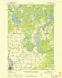 1951 Rice Lake1951 Print · USGSNorthwest Wisconsin’s lake country is captured in the early fifties, showing the transition from rail-dependent commerce to modern aviation. Researchers can trace dozens of country schoolhouses like Pioneer Sch and Lincoln Sch, or locate the Rice Lake Municipal Airport.
 - 1953 Map of Ashland, 1964 Print
 1953 Ashland1964 Print · USGSNorthern Wisconsin's lakefront and timberlands are seen here in the mid-1950s, showing the intersection of industrial rail lines and vast wilderness. Genealogists and historians can trace the Soo Line through rail towns like Mellen or locate family roots in the Apostle Islands and Bad River Indian Reservation.3 unique versions available
 - 1953 Map of Duluth, 1964 Print
 1953 Duluth1964 Print · USGSNortheastern Minnesota and northwestern Wisconsin are shown here during a period of industrial maturity and expanding conservation. Genealogists and historians can trace rail-connected towns like McGrath and Wahkon, or locate heritage sites within the Fond du Lac Indian Reservation.2 unique versions available
 - 1953 Map of Rice Lake, 1967 Print
 1953 Rice Lake1967 Print · USGSNorthwest Wisconsin during the mid-fifties reveals a landscape defined by timber, rail, and water. Genealogists and historians can trace the development of river towns like Ladysmith and Rice Lake along the Soo Line and Chicago and North Western railroads.2 unique versions available
 - 1953 Map of Stillwater, 1980 Print
 1953 Stillwater1980 Print · USGSThe Twin Cities and the St. Croix Valley are captured in this mid-century survey as the interstate era began to transform the Upper Midwest. Genealogists and historians can trace the rail-and-river geography of Stillwater, locate landmarks in Anoka, or explore the sprawling St Croix State Park.
 - 1955 Map of Hertel, 1957 Print
 1955 Hertel1957 Print · USGSNorthwest Wisconsin lakeland is captured here in the mid-fifties, centered on the community of Hertel. Researchers can pinpoint vanished rural institutions like Bashaw Brook Sch, North Dewey Sch, and the McKenzie Lake Lookout Tower.2 unique versions available
 - 1955 Map of Webb Lake, 1957 Print
 1955 Webb Lake1957 Print · USGSNorthwestern Wisconsin’s lake country is captured here in the mid-fifties, showing the confluence of the St. Croix and Namekagon rivers. Researchers can trace rural life through sites like Cozy Corner, the Webb Lake Sch, and the Dairyland Lookout Tower.2 unique versions available
 - 1955 Map of Stillwater, 1965 Print
 1955 Stillwater1965 Print · USGSThe Upper St. Croix Valley and the growing Twin Cities area are shown here during the mid-fifties, before the interstate era transformed the regional commute. You can trace the lines of the Northern Pacific RR through towns like Rush City or locate the Saint Croix Indian Reservation.
 - 1956 Map of Cumberland, 1957 Print
 1956 Cumberland1957 Print · USGSIn the mid-1950s, the lake country of Northwest Wisconsin was a patchwork of small townships and rural school districts. Genealogists can trace family connections through numerous local landmarks like Clam River Cem, Corpus Christi Ch, and the many rural schools like Bergman Sch and Emerson Sch.2 unique versions available
 - 1958 Map of Stillwater
 1958 Stillwater1958 Print · USGSThe Upper Mississippi and St. Croix River valleys appear in the mid-fifties as the Twin Cities expanded north. Genealogists can locate family landmarks like Oak Park Cem, Saint Michael Church, and the Soo Line RR rail corridors.2 unique versions available
 - 1958 Map of Ashland
 1958 Ashland1958 Print · USGSCoastal Wisconsin and the Michigan borderlands meet here in the late fifties, dominated by the timbered expanses and iron-rich ranges. Genealogists can trace family footprints in settlements like Odanah and Montreal, or locate landmarks such as the Coast Guard Station and Agricultural Experiment Station.
 - 1958 Map of Duluth
 1958 Duluth1958 Print · USGSNortheastern Minnesota and the Wisconsin borderlands are shown in detail during the late 1950s, centered on the bustling rail yards and ports of Duluth. You can trace the historic routes of the Soo Line and Duluth Missabe & Iron Range through small towns like McGrath, Bruno, and Wrenshall.
 - 1959 Map of Rice Lake
 1959 Rice Lake1959 Print · USGSNorthwest Wisconsin in the late fifties was a land of expanding road networks and deep-seated timber history. Genealogists and historians can trace rail lines like the Soo Line RR and Chicago St Paul Minneapolis and Omaha Ry as they link settlements from Spooner to Medford.
End of results
Showing maps 1-16 of 16
Top cities of Washburn County
- Spooner historical maps
- Shell Lake historical maps
- Trego historical maps
- Beaver Brook historical maps
- Minong historical maps
- Springbrook historical maps
See more
Frequently asked questions
- What are the different types of historical maps available for Washburn County?
- What is the oldest map of Washburn County?
- Where can I purchase historical maps of Washburn County for my home or office?
- Where can I download high-res historical maps of Washburn County?
- Are there historical topographic maps available for Washburn County?
- Is there historical aerial imagery available for Washburn County?
- Where are historical maps of Washburn County sourced from?