Old Maps of Minong, Wisconsin for Academic Research
Study the evolution of Minong with 8 high-resolution historic maps. Whether you're teaching, researching, or modeling changes in land use, these maps provide essential visual documentation of urban, environmental, and geographic change.
- Analyze long-term change: Track patterns in development, transportation, and natural features.
- Ideal for environmental or urban studies: Support academic projects with primary historical map data.
- Use in the classroom or lab: Educators and researchers rely on these maps to bring historical context to life.
These maps are a powerful tool for teaching, research, and visualizing how Minong has changed over the decades.
Minong, WI maps
(8)- 1947 Map of Minong, 1964 Print
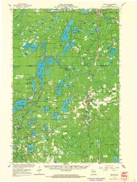
 1947 Minong1964 Print · USGSNorthwest Wisconsin's lake country is captured here in the late 1940s as rail and road corridors began to open the woods for more permanent settlement. Genealogists can locate family-named landmarks and rural hubs like Wascott Ch, Hoover Sch, and the village of Minong.
 - 1949 Map of Minong
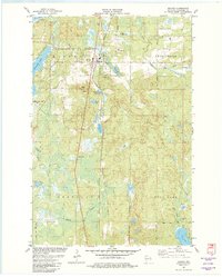
 1949 Minong1949 Print · USGSNorthwestern Wisconsin’s lake country is captured here in the late 1940s, when the North Western railroad still linked small timber and rail towns. Researchers can locate vanished landmarks like Hoover Sch, Wascott Ch, and the small settlement of Lakeside.
 - 1953 Map of Ashland, 1964 Print
 1953 Ashland1964 Print · USGSNorthern Wisconsin's lakefront and timberlands are seen here in the mid-1950s, showing the intersection of industrial rail lines and vast wilderness. Genealogists and historians can trace the Soo Line through rail towns like Mellen or locate family roots in the Apostle Islands and Bad River Indian Reservation.3 unique versions available
 - 1958 Map of Ashland
 1958 Ashland1958 Print · USGSCoastal Wisconsin and the Michigan borderlands meet here in the late fifties, dominated by the timbered expanses and iron-rich ranges. Genealogists can trace family footprints in settlements like Odanah and Montreal, or locate landmarks such as the Coast Guard Station and Agricultural Experiment Station.
 - 1965 Map of Minong, 1967 Print
 1965 Minong1967 Print · USGSWashburn and Douglas counties are shown here in the mid-sixties during a period of expanding forest management and rail-based commerce. Researchers can locate family sites and landmarks like Wascott Cemetery, Sutherland Landing Field, and the Minong settlement.
 - 1980 Map of Solon Springs
 1980 Solon Springs1980 Print · USGSNorthern Wisconsin in the early eighties was a landscape of dense timber and sprawling glacial waters. Trace the legacy of the Chicago and North Western rail line through Solon Springs, Hayward, and Minong at this pivotal moment.
 - 1982 Map of Minong
 1982 Minong1982 Print · USGSWashburn County in the early eighties is a landscape of glacial lakes and rail-line villages. Researchers can trace the Chicago and North Western railroad through Minong, locating Greenwood Cem and the settlement at Stuntz.
 - 2022 Map of Minong, 2022 Print
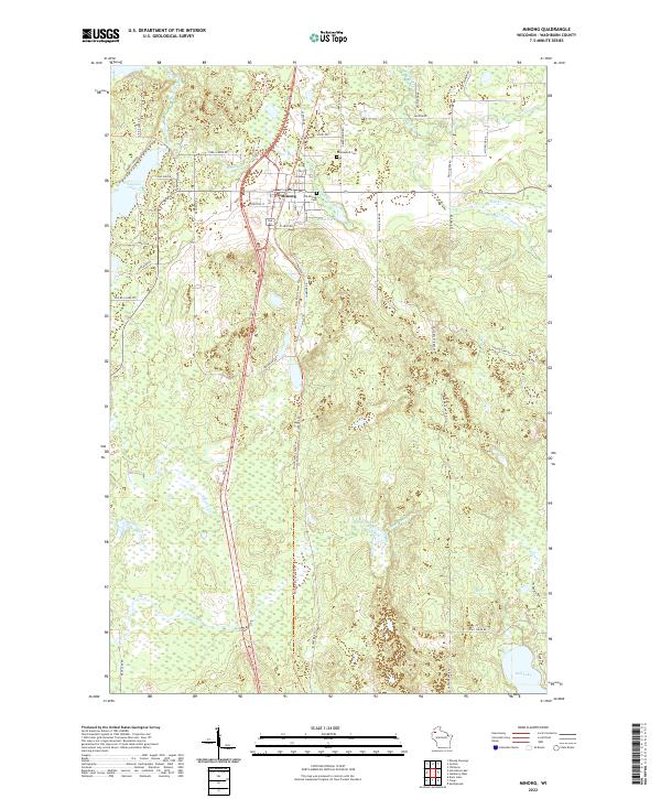 2022 Minong2022 Print · USGSMinong and the surrounding northwoods of Washburn County are captured here in the early twenty-first century. Genealogists can locate family landmarks like Old Minong Cem and Greenwood Cem, or trace the path of the Wild Rivers State Trl past Bond Lake.
End of results
Showing maps 1-8 of 8
Top cities near Minong
- Trego historical maps
- Gordon historical maps
- Wascott historical maps
- Springbrook historical maps
- Webb Lake historical maps
- Dairyland historical maps
Frequently asked questions
- What are the different types of historical maps available for Minong?
- What is the oldest map of Minong?
- Where can I purchase historical maps of Minong for my home or office?
- Where can I download high-res historical maps of Minong?
- Are there historical topographic maps available for Minong?
- Is there historical aerial imagery available for Minong?
- Where are historical maps of Minong sourced from?