1960s Maps of Alpine Northeast, Wyoming
Explore 3 historic maps of Alpine Northeast from the 1960s. These maps offer a rare glimpse into what life looked like during the 1960s — showing old roads, neighborhoods, homes, and landmarks that have changed or disappeared over time.
Whether you're researching your family's past, planning a metal detecting trip, or studying how Alpine Northeast's landscape evolved across the 1960s, these high-resolution maps are a powerful tool for exploring the history of this region.
- Focus on a specific era: All maps on this page are from the 1960s, giving you a focused view of this time period.
- See what’s changed: Compare century-old streets, trails, and buildings to today's modern landscape using overlays and satellite layers.
- Research with precision: Use these maps for genealogy, historical research, land use analysis, or educational projects.
- View, download, or print: Maps are fully viewable online in high resolution, and can be downloaded or printed for your own records.
Start exploring Alpine Northeast's history through authentic maps from the 1960s. This is your window into the past.
Alpine Northeast, WY maps
(3)- 1962 Map of Driggs
 1962 Driggs1962 Print · USGSThe Idaho-Wyoming borderlands are captured here in the early sixties, showing the peaks and valleys of the northern Rockies. Genealogists and historians can trace rail lines like the Union Pacific RR and isolated outposts like the National Elk Refuge or the Fort Hall Indian Reservation.
 - 1963 Map of Ferry Peak, 1967 Print
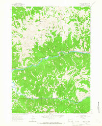 1963 Ferry Peak1967 Print · USGSThe Grand Canyon of the Snake River remains largely wild in the early sixties, defined by its high peaks and forest service campgrounds. Researchers can trace historic routes like the Indian Creek Trail or locate the Gaging Station near the Greys River junction.
 - 1966 Map of Alpine, 1969 Print
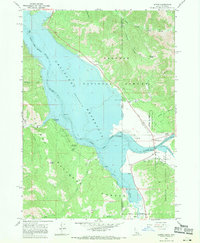 1966 Alpine1969 Print · USGSThe confluence of the Snake and Salt Rivers is captured here in the mid-1960s, just as the Palisades Reservoir shaped the modern landscape. Researchers can trace the early layout of Alpine, locate the Alpine Post Office, and find recreation sites like McCoy Creek Campground.4 unique versions available
End of results
Showing maps 1-3 of 3
Top cities near Alpine Northeast
Frequently asked questions
- What are the different types of historical maps available for Alpine Northeast?
- What is the oldest map of Alpine Northeast?
- Where can I purchase historical maps of Alpine Northeast for my home or office?
- Where can I download high-res historical maps of Alpine Northeast?
- Are there historical topographic maps available for Alpine Northeast?
- Is there historical aerial imagery available for Alpine Northeast?
- Where are historical maps of Alpine Northeast sourced from?