1900s (20th Century) Maps of Thayne, Wyoming
Explore 9 historic maps of Thayne from the 1900s (20th Century). These maps offer a rare glimpse into what life looked like during the 1900s — showing old roads, neighborhoods, homes, and landmarks that have changed or disappeared over time.
Whether you're researching your family's past, planning a metal detecting trip, or studying how Thayne's landscape evolved across the 1900s, these high-resolution maps are a powerful tool for exploring the history of this region.
- Focus on a specific era: All maps on this page are from the 1900s, giving you a focused view of this time period.
- See what’s changed: Compare century-old streets, trails, and buildings to today's modern landscape using overlays and satellite layers.
- Research with precision: Use these maps for genealogy, historical research, land use analysis, or educational projects.
- View, download, or print: Maps are fully viewable online in high resolution, and can be downloaded or printed for your own records.
Start exploring Thayne's history through authentic maps from the 1900s. This is your window into the past.
Thayne, WY maps
(9)- 1915 Map of Freedom
 1915 Freedom1915 Print · USGSThe Idaho-Wyoming border comes alive in this survey of the high mountain ranges and irrigated valleys during the early twentieth century. Researchers can trace the path of the Lander Cutoff and locate early community landmarks like the Freedom School or the Old Salt Works.3 unique versions available
 - 1921 Map of Afton
 1921 Afton1921 Print · USGSStar Valley and the high Wyoming backcountry are captured here in the early twenties, showing the region's early ranching and forestry roots. Researchers can locate early schools like Muddy String School, isolated outposts like Moffat Ranch, and forest service sites including Corral Creek Ranger Sta.
 - 1955 Map of Preston, 1968 Print
 1955 Preston1968 Print · USGSSoutheast Idaho and western Wyoming are shown in detail during the mid-fifties, from the high Bear River Range to the Green River Basin. Genealogists and collectors can trace the Union Pacific RR through historic towns like Preston, Montpelier, and Afton.3 unique versions available
 - 1958 Map of Preston
 1958 Preston1958 Print · USGSThe high valleys of the Idaho and Wyoming borderlands are captured here in the late fifties, showcasing a landscape of mountain ranching and phosphate mining. Genealogists and historians can locate early settlements like Chesterfield and Bedford or trace the Union Pacific rail lines serving Cokeville.2 unique versions available
 - 1962 Map of Preston
 1962 Preston1962 Print · USGSSoutheast Idaho and the Wyoming borderlands are captured here in the early sixties, a time of thriving agricultural valleys and mountain ranching. Researchers can trace the Union Pacific rail lines and find legacy settlements like Montpelier, Afton, and Preston.
 - 1980 Map of Thayne West
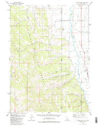 1980 Thayne West1980 Print · USGSThe Star Valley region on the Idaho-Wyoming border thrived as a high-altitude agricultural hub in the early 1980s. Researchers can trace historical irrigation networks like Baker Ditch and locate local landmarks such as Haderlie Knoll and the Cem in Freedom.3 unique versions available
 - 1980 Map of Thayne East, 1981 Print
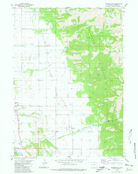 1980 Thayne East1981 Print · USGSStar Valley ranching and irrigation are captured here in the early 1980s as the communities of Thayne and Bedford grew along the Salt River. Researchers can trace local landmarks like the Bedford Cem, Holdaway Sch, and the network of water-moving systems like the Hardman Ditch.
 - 1982 Map of Afton
 1982 Afton1982 Print · USGSWestern Wyoming during the early eighties shows a landscape of mountain ranges and valley settlements. Genealogists can trace family names and small towns across Star Valley, while historians can locate the path of the Lander Cutoff and the Cottonwood Mine.
 - 1982 Map of Soda Springs
 1982 Soda Springs1982 Print · USGSSoutheast Idaho and the Wyoming borderlands come alive in the early eighties as a landscape of mountain ranges and industrial valleys. Genealogists and historians can locate remote family plots like Lund Cem or trace the early paths through Fivemile Meadows and the Fort Hall Indian Reservation.2 unique versions available
End of results
Showing maps 1-9 of 9
Top cities near Thayne
Frequently asked questions
- What are the different types of historical maps available for Thayne?
- What is the oldest map of Thayne?
- Where can I purchase historical maps of Thayne for my home or office?
- Where can I download high-res historical maps of Thayne?
- Are there historical topographic maps available for Thayne?
- Is there historical aerial imagery available for Thayne?
- Where are historical maps of Thayne sourced from?