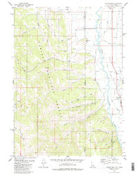
1980 Map of Thayne West
USGS Topo · Published 1980About this map
Freedom and Thayne sit within the high Star Valley, where the Idaho-Wyoming state line splits the community of Freedom down its main thoroughfare. The landscape transitions sharply from the fertile agricultural flats of the Salt River basin to the steep, wooded slopes of the Caribou National Forest. Water management is central to this valley’s economy, evidenced by a network of irrigation works like Baker Ditch, the Side Canal, and the East Side Canal that diverted mountain runoff to the valley floor. To the west, the terrain rises into prominent features like Old Man Ridge and Haderlie Knoll, while numerous drainages such as Tincup Creek and Allred Mill Creek Canyon cut through the forest. Several Gravel Pits and a Cem near the border reflect the local industry and long-standing settlement of this remote mountain border region.
Find a feature on this map
37 named features on this map. Tap any name to fly to it.
Don’t see what you’re looking for? This feature index may not catch every label — zoom into the map to look around manually.
Map Details
Editions of this 1980 Thayne West Map
3 editions found
Other maps of this area

1915 · Freedom
USGS Topo · 1:62,500

1921 · Afton
USGS Topo · 1:125,000

1931 · Jackson
USGS Topo · 1:125,000

1932 · Irwin
USGS Topo · 1:96,000

1935 · Irwin
USGS Topo · 1:125,000

1935 · Jackson
USGS Topo · 1:125,000

1955 · Driggs
USGS Topo · 1:250,000

1955 · Preston
USGS Topo · 1:250,000

1958 · Driggs
USGS Topo · 1:250,000

1958 · Preston
USGS Topo · 1:250,000