1980s Maps of Badger Basin, Wyoming
Explore 2 historic maps of Badger Basin from the 1980s. These maps offer a rare glimpse into what life looked like during the 1980s — showing old roads, neighborhoods, homes, and landmarks that have changed or disappeared over time.
Whether you're researching your family's past, planning a metal detecting trip, or studying how Badger Basin's landscape evolved across the 1980s, these high-resolution maps are a powerful tool for exploring the history of this region.
- Focus on a specific era: All maps on this page are from the 1980s, giving you a focused view of this time period.
- See what’s changed: Compare century-old streets, trails, and buildings to today's modern landscape using overlays and satellite layers.
- Research with precision: Use these maps for genealogy, historical research, land use analysis, or educational projects.
- View, download, or print: Maps are fully viewable online in high resolution, and can be downloaded or printed for your own records.
Start exploring Badger Basin's history through authentic maps from the 1980s. This is your window into the past.
Badger Basin, WY maps
(2)- 1980 Map of Cody, 1982 Print
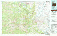 1980 Cody1982 Print · USGSThe Cody region in the early 1980s reveals a rugged wilderness of the Shoshone National Forest meeting the plains. Researchers can trace the Burlington Northern rail line and locate landmarks like Painter Mine and Buffalo Bill Reservoir.3 unique versions available
 - 1987 Map of Badger Basin
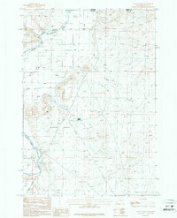 1987 Badger Basin1987 Print · USGSPark County, Wyoming, near the Montana line, is shown in the late 1980s as a hub of river-valley irrigation and industrial activity. Researchers can trace the water-management systems of the Clarks Fork Yellowstone River, including the Sirrine DITCH and several Aqueduct segments.
End of results
Showing maps 1-2 of 2
Frequently asked questions
- What are the different types of historical maps available for Badger Basin?
- What is the oldest map of Badger Basin?
- Where can I purchase historical maps of Badger Basin for my home or office?
- Where can I download high-res historical maps of Badger Basin?
- Are there historical topographic maps available for Badger Basin?
- Is there historical aerial imagery available for Badger Basin?
- Where are historical maps of Badger Basin sourced from?