1980s Maps of Wapiti, Wyoming
Explore 2 historic maps of Wapiti from the 1980s. These maps offer a rare glimpse into what life looked like during the 1980s — showing old roads, neighborhoods, homes, and landmarks that have changed or disappeared over time.
Whether you're researching your family's past, planning a metal detecting trip, or studying how Wapiti's landscape evolved across the 1980s, these high-resolution maps are a powerful tool for exploring the history of this region.
- Focus on a specific era: All maps on this page are from the 1980s, giving you a focused view of this time period.
- See what’s changed: Compare century-old streets, trails, and buildings to today's modern landscape using overlays and satellite layers.
- Research with precision: Use these maps for genealogy, historical research, land use analysis, or educational projects.
- View, download, or print: Maps are fully viewable online in high resolution, and can be downloaded or printed for your own records.
Start exploring Wapiti's history through authentic maps from the 1980s. This is your window into the past.
Wapiti, WY maps
(2)- 1980 Map of Carter Mountain, 1982 Print
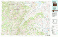 1980 Carter Mountain1982 Print · USGSPark County at the dawn of the 1980s reveals a high-country landscape where mountain wilderness meets energy extraction. Researchers can locate remote outposts like Irma, trace the Greybull River valley, and identify the footprint of the Pitchfork Oil Field or Sunshine Reservoir.3 unique versions available
 - 1988 Map of Wapiti
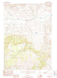 1988 Wapiti1988 Print · USGSThe North Fork Shoshone River valley in the late 1980s reveals a rugged mountain landscape shaped by ranching and wilderness. Researchers can trace land use from the Wapiti settlement to remote outposts like Diamond Bar Cow Camp and the Stonebridge Reservoir.
End of results
Showing maps 1-2 of 2
Frequently asked questions
- What are the different types of historical maps available for Wapiti?
- What is the oldest map of Wapiti?
- Where can I purchase historical maps of Wapiti for my home or office?
- Where can I download high-res historical maps of Wapiti?
- Are there historical topographic maps available for Wapiti?
- Is there historical aerial imagery available for Wapiti?
- Where are historical maps of Wapiti sourced from?