Old Maps of Wapiti, Wyoming for Hiking & Exploration
Hike through history with 8 historic maps of Wapiti. Explore old trails, ghost towns, and forgotten backroads — perfect for outdoor adventurers and local explorers.
- Rediscover forgotten places: Map out old mining camps, roads, and footpaths that no longer exist on modern maps.
- Layer with modern tools: Combine with LiDAR or satellite views to plan hikes through historical terrain.
- Made for exploration: Popular among hikers, overlanders, and local history lovers.
Use these maps to find adventure and explore the hidden past of Wapiti.
Wapiti, WY maps
(8)- 1955 Map of Cody, 1969 Print
 1955 Cody1969 Print · USGSThe Bighorn Basin and Absaroka Range meet in the mid-fifties, capturing a landscape defined by mountain wilderness and burgeoning oil fields. Trace family roots in Cody or Meeteetse, and locate industrial landmarks like the Elk Basin Oil and Gas Field and the Chicago Burlington and Quincy RR.2 unique versions available
 - 1957 Map of Wapiti, 1959 Print
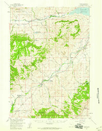 1957 Wapiti1959 Print · USGSThe Shoshone River valley comes alive in the late fifties, showcasing a network of working ranches and mountain lodges at the edge of the wilderness. Genealogists and historians can trace family-named sites like Siggins Brothers Ranch or locate the Hardpan Sch and Ishawooa Guard Sta.2 unique versions available
 - 1958 Map of Cody
 1958 Cody1958 Print · USGSNorthwestern Wyoming at the peak of the mid-century energy and ranching boom shows a land of high peaks and oil basins. Researchers can trace the Chicago Burlington and Quincy rail lines through Greybull or locate the sprawling Elk Basin Oil and Gas Field.
 - 1962 Map of Cody
 1962 Cody1962 Print · USGSBig Horn Basin energy and agriculture define this mid-century look at Wyoming’s northern frontier. Local historians can trace the irrigation and rail networks connecting Cody and Powell to major energy sites like the Oregon Basin Oil Field.
 - 1980 Map of Carter Mountain, 1982 Print
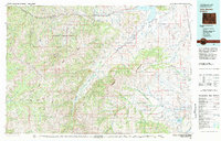 1980 Carter Mountain1982 Print · USGSPark County at the dawn of the 1980s reveals a high-country landscape where mountain wilderness meets energy extraction. Researchers can locate remote outposts like Irma, trace the Greybull River valley, and identify the footprint of the Pitchfork Oil Field or Sunshine Reservoir.3 unique versions available
 - 1988 Map of Wapiti
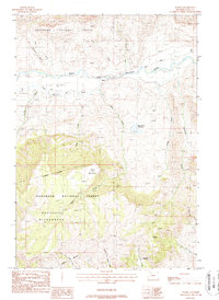 1988 Wapiti1988 Print · USGSThe North Fork Shoshone River valley in the late 1980s reveals a rugged mountain landscape shaped by ranching and wilderness. Researchers can trace land use from the Wapiti settlement to remote outposts like Diamond Bar Cow Camp and the Stonebridge Reservoir.
 - 1991 Map of Wapiti, 1996 Print
 1991 Wapiti1996 Print · USGSThe North Fork Shoshone River valley in the early nineties remained a vital corridor for high-country ranching and recreation. Researchers can locate family-named landmarks like Bradford Ranch and Dahlman Ranch alongside the settlement of Wapiti.2 unique versions available
 - 2021 Map of Wapiti, 2021 Print
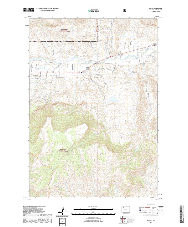 2021 Wapiti2021 Print · USGSWapiti and the Shoshone River valley are documented here in recent years, showing a community defined by its mountain geography. Researchers can trace local landmarks like the Wapiti Valley Church, the Cem, and historical routes like the Stagecoach Trl.
End of results
Showing maps 1-8 of 8
Frequently asked questions
- What are the different types of historical maps available for Wapiti?
- What is the oldest map of Wapiti?
- Where can I purchase historical maps of Wapiti for my home or office?
- Where can I download high-res historical maps of Wapiti?
- Are there historical topographic maps available for Wapiti?
- Is there historical aerial imagery available for Wapiti?
- Where are historical maps of Wapiti sourced from?