1900s (20th Century) Maps of Chugwater, Wyoming
Explore 11 historic maps of Chugwater from the 1900s (20th Century). These maps offer a rare glimpse into what life looked like during the 1900s — showing old roads, neighborhoods, homes, and landmarks that have changed or disappeared over time.
Whether you're researching your family's past, planning a metal detecting trip, or studying how Chugwater's landscape evolved across the 1900s, these high-resolution maps are a powerful tool for exploring the history of this region.
- Focus on a specific era: All maps on this page are from the 1900s, giving you a focused view of this time period.
- See what’s changed: Compare century-old streets, trails, and buildings to today's modern landscape using overlays and satellite layers.
- Research with precision: Use these maps for genealogy, historical research, land use analysis, or educational projects.
- View, download, or print: Maps are fully viewable online in high resolution, and can be downloaded or printed for your own records.
Start exploring Chugwater's history through authentic maps from the 1900s. This is your window into the past.
Chugwater, WY maps
- 1953 Map of Chugwater, 1954 Print
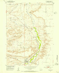 1953 Chugwater1954 Print · USGSThe Chugwater valley in the early fifties was a hub of rail activity and high-plains ranching as part of the Missouri River Basin development. Researchers can locate the Grain Elevators in Chugwater, the route of the Colorado and Southern railroad, and landmarks like Chimney Rock.2 unique versions available
 - 1954 Map of Cheyenne, 1963 Print
 1954 Cheyenne1963 Print · USGSSoutheastern Wyoming's high plains and the capital city's mid-century expansion are documented here during the early Cold War. Genealogists and historians can trace rail-aligned settlements like Pine Bluffs and Hillsdale, or explore landmarks like the Ames Monument and Francis E. Warren Air Force Base.3 unique versions available
 - 1958 Map of Cheyenne
 1958 Cheyenne1958 Print · USGSSoutheast Wyoming and the Nebraska border appear in the late 1950s as a hub of military defense and rail commerce. Genealogists can trace the Union Pacific through Cheyenne or locate the Horse Creek Oil Field and the State Capitol.2 unique versions available
 - 1962 Map of Bristol Ridge NE, 1965 Print
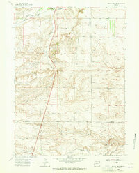 1962 Bristol Ridge NE1965 Print · USGSThe high plains of Wyoming are captured here in the early sixties, illustrating the critical transportation corridor between Platte and Laramie counties. Researchers can trace the Colorado and Southern railroad, find family landmarks near Bristol Ridge, and locate natural features like Mud Spring.2 unique versions available
 - 1990 Map of Chugwater, 1995 Print
 1990 Chugwater1995 Print · USGSSoutheastern Wyoming's high plains landscape comes into focus here during the late twentieth century. Researchers can trace the agricultural heart of Chugwater through its Grain Elevators or locate old settlements like Slater and Lathrum.
 - 1990 Map of Bristol Ridge NE, 1995 Print
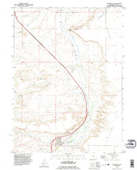
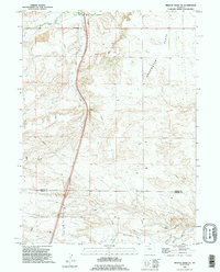 1990 Bristol Ridge NE1995 Print · USGSThe high plains of Platte and Laramie counties are captured here in the early nineties, showcasing the intersection of ranching land and industrial infrastructure. Researchers can trace the rugged topography from Bristol Ridge down to Chugwater Creek and locate several Oil Well sites.
End of results
Showing maps 1-6
Frequently asked questions
- What are the different types of historical maps available for Chugwater?
- What is the oldest map of Chugwater?
- Where can I purchase historical maps of Chugwater for my home or office?
- Where can I download high-res historical maps of Chugwater?
- Are there historical topographic maps available for Chugwater?
- Is there historical aerial imagery available for Chugwater?
- Where are historical maps of Chugwater sourced from?