1980s Maps of Elkhorn Junction, Wyoming
Explore 2 historic maps of Elkhorn Junction from the 1980s. These maps offer a rare glimpse into what life looked like during the 1980s — showing old roads, neighborhoods, homes, and landmarks that have changed or disappeared over time.
Whether you're researching your family's past, planning a metal detecting trip, or studying how Elkhorn Junction's landscape evolved across the 1980s, these high-resolution maps are a powerful tool for exploring the history of this region.
- Focus on a specific era: All maps on this page are from the 1980s, giving you a focused view of this time period.
- See what’s changed: Compare century-old streets, trails, and buildings to today's modern landscape using overlays and satellite layers.
- Research with precision: Use these maps for genealogy, historical research, land use analysis, or educational projects.
- View, download, or print: Maps are fully viewable online in high resolution, and can be downloaded or printed for your own records.
Start exploring Elkhorn Junction's history through authentic maps from the 1980s. This is your window into the past.
Elkhorn Junction, WY maps
(2)- 1980 Map of Farson, 1981 Print
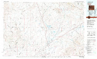 1980 Farson1981 Print · USGSSettlement in the high desert of Sweetwater County is centered on Farson and Eden during the 1980s. Researchers can trace the path of the Dry Sandy Stage and Pony Express Sta (Site) and explore the vast Sand Dunes near Steamboat Rim.
 - 1986 Map of Prospect Mountains
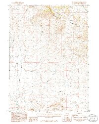 1986 Prospect Mountains1986 Print · USGSSublette County ranching and water management are recorded in the mid-eighties as they intersect with the Continental Divide. Researchers can trace the path of the Elkhorn Ditch and locate landmarks like Elkhorn Junction and Prospect Reservoir.
End of results
Showing maps 1-2 of 2
Frequently asked questions
- What are the different types of historical maps available for Elkhorn Junction?
- What is the oldest map of Elkhorn Junction?
- Where can I purchase historical maps of Elkhorn Junction for my home or office?
- Where can I download high-res historical maps of Elkhorn Junction?
- Are there historical topographic maps available for Elkhorn Junction?
- Is there historical aerial imagery available for Elkhorn Junction?
- Where are historical maps of Elkhorn Junction sourced from?