1900s (20th Century) Maps of Elkhorn Junction, Wyoming
Explore 6 historic maps of Elkhorn Junction from the 1900s (20th Century). These maps offer a rare glimpse into what life looked like during the 1900s — showing old roads, neighborhoods, homes, and landmarks that have changed or disappeared over time.
Whether you're researching your family's past, planning a metal detecting trip, or studying how Elkhorn Junction's landscape evolved across the 1900s, these high-resolution maps are a powerful tool for exploring the history of this region.
- Focus on a specific era: All maps on this page are from the 1900s, giving you a focused view of this time period.
- See what’s changed: Compare century-old streets, trails, and buildings to today's modern landscape using overlays and satellite layers.
- Research with precision: Use these maps for genealogy, historical research, land use analysis, or educational projects.
- View, download, or print: Maps are fully viewable online in high resolution, and can be downloaded or printed for your own records.
Start exploring Elkhorn Junction's history through authentic maps from the 1900s. This is your window into the past.
Elkhorn Junction, WY maps
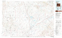
(6)- 1955 Map of Lander, 1976 Print
 1955 Lander1976 Print · USGSMid-century central Wyoming is captured here as a landscape of high alpine wilderness and burgeoning energy development. Genealogists and historians can trace the path of the Oregon Trail or locate early industrial sites like the Big Sand Draw Oil and Gas Field and the State Training School.2 unique versions available
 - 1958 Map of Lander
 1958 Lander1958 Print · USGSThe high peaks of the Wind River Range meet the Great Divide Basin in the 1950s. Researchers can trace historic migrations past the Oregon Trail Monument or locate early energy infrastructure at the Beaver Creek Gas and Oil Field and the Oregon Trail Oil Field.
 - 1958 Map of Parting of the Ways, 1960 Print
 1958 Parting of the Ways1960 Print · USGSSouthwestern Wyoming’s high desert was the crossroads of the westward expansion in the late fifties. Trace the legendary Parting of the Ways, the Dry Sandy Stage and Pony Express Sta Site, and the Sublette Cutoff.2 unique versions available
 - 1961 Map of Lander
 1961 Lander1961 Print · USGSThe high peaks and desert basins of central Wyoming appear here in the early sixties, showing the landscape of the Shoshone Indian Reservation and the Wind River Range. Researchers can trace the path of the Oregon Trail and locate early settlements like Lander and the mining remains at South Pass City.2 unique versions available
 - 1980 Map of Farson, 1981 Print
 1980 Farson1981 Print · USGSSettlement in the high desert of Sweetwater County is centered on Farson and Eden during the 1980s. Researchers can trace the path of the Dry Sandy Stage and Pony Express Sta (Site) and explore the vast Sand Dunes near Steamboat Rim.
 - 1986 Map of Prospect Mountains
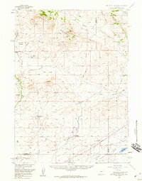
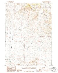 1986 Prospect Mountains1986 Print · USGSSublette County ranching and water management are recorded in the mid-eighties as they intersect with the Continental Divide. Researchers can trace the path of the Elkhorn Ditch and locate landmarks like Elkhorn Junction and Prospect Reservoir.
End of results
Showing maps 1-6 of 6
Frequently asked questions
- What are the different types of historical maps available for Elkhorn Junction?
- What is the oldest map of Elkhorn Junction?
- Where can I purchase historical maps of Elkhorn Junction for my home or office?
- Where can I download high-res historical maps of Elkhorn Junction?
- Are there historical topographic maps available for Elkhorn Junction?
- Is there historical aerial imagery available for Elkhorn Junction?
- Where are historical maps of Elkhorn Junction sourced from?