1980s Maps of Green River, Wyoming
Explore 4 historic maps of Green River from the 1980s. These maps offer a rare glimpse into what life looked like during the 1980s — showing old roads, neighborhoods, homes, and landmarks that have changed or disappeared over time.
Whether you're researching your family's past, planning a metal detecting trip, or studying how Green River's landscape evolved across the 1980s, these high-resolution maps are a powerful tool for exploring the history of this region.
- Focus on a specific era: All maps on this page are from the 1980s, giving you a focused view of this time period.
- See what’s changed: Compare century-old streets, trails, and buildings to today's modern landscape using overlays and satellite layers.
- Research with precision: Use these maps for genealogy, historical research, land use analysis, or educational projects.
- View, download, or print: Maps are fully viewable online in high resolution, and can be downloaded or printed for your own records.
Start exploring Green River's history through authentic maps from the 1980s. This is your window into the past.
Green River, WY maps
(4)- 1980 Map of Firehole Canyon, 1993 Print
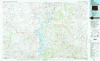 1980 Firehole Canyon1993 Print · USGSSweetwater County and the tri-state border region are mapped here in the early eighties as the reservoir system reshaped the high desert. Researchers can trace remote settlements like McKinnon and landforms such as Massacre Hill and the Red Creek Badlands.2 unique versions available
 - 1981 Map of Rock Springs
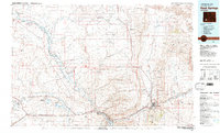 1981 Rock Springs1981 Print · USGSSweetwater County at the start of the 1980s shows a landscape of industrial energy and historic routes. Trace the path of the Emigrant Trail past Little America or explore mining sites like Westvaco Shaft No 1.
 - 1987 Map of Blacks Fork Bridge
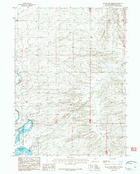 1987 Blacks Fork Bridge1987 Print · USGSSweetwater County during the late eighties shows a landscape shaped by utility corridors and the expansive Flaming Gorge Reservoir. Researchers can trace the path of Lost Dog Road and locate the historic river crossing at Blacks Fork Bridge.
 - 1987 Map of Whalen Butte
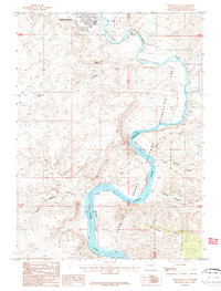 1987 Whalen Butte1987 Print · USGSThe Green River canyons of Sweetwater County are captured here in the 1980s just as the reservoir reshaped the valley. Researchers can trace historic river bottoms and landmarks like Whalen Butte, Whiskey Bend, and the Green River Airport.
End of results
Showing maps 1-4 of 4
Top cities near Green River
- Rock Springs historical maps
- North Rock Springs historical maps
- Clearview Acres historical maps
- James Town historical maps
- Purple Sage historical maps
Frequently asked questions
- What are the different types of historical maps available for Green River?
- What is the oldest map of Green River?
- Where can I purchase historical maps of Green River for my home or office?
- Where can I download high-res historical maps of Green River?
- Are there historical topographic maps available for Green River?
- Is there historical aerial imagery available for Green River?
- Where are historical maps of Green River sourced from?