1950s Maps of Green River, Wyoming
Explore 4 historic maps of Green River from the 1950s. These maps offer a rare glimpse into what life looked like during the 1950s — showing old roads, neighborhoods, homes, and landmarks that have changed or disappeared over time.
Whether you're researching your family's past, planning a metal detecting trip, or studying how Green River's landscape evolved across the 1950s, these high-resolution maps are a powerful tool for exploring the history of this region.
- Focus on a specific era: All maps on this page are from the 1950s, giving you a focused view of this time period.
- See what’s changed: Compare century-old streets, trails, and buildings to today's modern landscape using overlays and satellite layers.
- Research with precision: Use these maps for genealogy, historical research, land use analysis, or educational projects.
- View, download, or print: Maps are fully viewable online in high resolution, and can be downloaded or printed for your own records.
Start exploring Green River's history through authentic maps from the 1950s. This is your window into the past.
Green River, WY maps
(4)- 1954 Map of Rock Springs, 1969 Print
 1954 Rock Springs1969 Print · USGSSouthern Wyoming at the peak of the mid-century energy boom is defined by the vital rail corridor and the high desert of the Red Desert Basin. Trace the development of mining towns like Superior and Reliance alongside the Union Pacific RR and historical landmarks like Pilot Butte.2 unique versions available
 - 1957 Map of Mc Kinnon Junction, 1959 Print
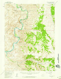
 1957 Mc Kinnon Junction1959 Print · USGSSweetwater County ranching and river basins are captured here in the late fifties, showing the complex meanders of the Blacks Fork River. Researchers can trace old family holdings like Bonoma Ranch and Holmes Ranch or locate the site of Massacre Hill.
 - 1957 Map of Firehole Basin, 1959 Print
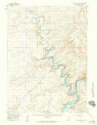
 1957 Firehole Basin1959 Print · USGSThe Green River corridor in Sweetwater County is shown here in the late fifties, shortly before the landscape was altered by the Flaming Gorge project. Researchers can trace remote homesteads like Kincaid Ranch and unique riverside features including Whiskey Bend and Slippery Jim Bottom.
 - 1958 Map of Rock Springs
 1958 Rock Springs1958 Print · USGSThe high desert of Sweetwater County comes into focus during the mid-1950s, centered on the rail-and-road corridor through Rock Springs. Genealogists and historians can trace family landholdings and infrastructure at Barnhart Ranch, Little America, and the Union Pacific line.2 unique versions available
End of results
Showing maps 1-4 of 4
Top cities near Green River
- Rock Springs historical maps
- North Rock Springs historical maps
- Clearview Acres historical maps
- James Town historical maps
- Purple Sage historical maps
Frequently asked questions
- What are the different types of historical maps available for Green River?
- What is the oldest map of Green River?
- Where can I purchase historical maps of Green River for my home or office?
- Where can I download high-res historical maps of Green River?
- Are there historical topographic maps available for Green River?
- Is there historical aerial imagery available for Green River?
- Where are historical maps of Green River sourced from?