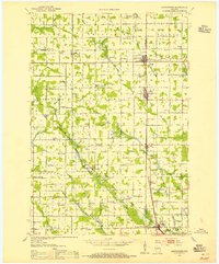
1953 Map of Abbotsford
USGS Topo · Published 1955About this map
Abbotsford and Spencer anchor this mid-century survey of the central Wisconsin dairy lands, where the Minneapolis St Paul and Sault Ste Marie railroad defines the corridor of settlement. The landscape is a dense grid of rural education and faith, marked by dozens of small institutions like Bee Hive Sch and St Pauls Ch. This specific era shows the transition of rural infrastructure, noting the Sunshine Sch (Abandoned) and an Old Railroad Grade north of Curtiss.
Find a feature on this map
74 named features on this map. Tap any name to fly to it.
Don’t see what you’re looking for? This feature index may not catch every label — zoom into the map to look around manually.
Map Details
Editions of this 1953 Abbotsford Map
This is the sole edition of this map. No revisions or reprints were ever made.
Other maps of this area

1902 · Marathon
USGS Topo · 1:125,000
1951 · Lublin
USGS Topo · 1:48,000
1951 · Athens
USGS Topo · 1:48,000
1951 · Medford
USGS Topo · 1:48,000
1953 · Neillsville
USGS Topo · 1:62,500
1953 · Owen
USGS Topo · 1:48,000
1953 · Stratford
USGS Topo · 1:48,000

1953 · Eau Claire
USGS Topo · 1:250,000

1953 · Rice Lake
USGS Topo · 1:250,000
1954 · Granton
USGS Topo · 1:62,500