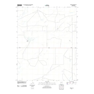
2010 Map of Abbott
USGS Topo · Published 2010About this map
Abbott serves as the primary junction point in this northeast New Mexico landscape, where Highway 56 412 intersects with a network of rural routes. The terrain is defined by its seasonal water features and drainage systems, notably the branching paths of Jaritas Arroyo and the presence of Big Lake, which is regulated by the Jaritas Number Two Dam. Small ranching or residential clusters such as Montoya, Gillespie, and Messick are scattered across the high plains, connected by a grid of county roads including County Road C-67 and County Road C-48. The map also captures the isolated settlement of Jones and the riparian corridor of Sauz Creek in the south, illustrating a sparse, agriculture-oriented settlement pattern characteristic of the region. The relationship between these intermittent water sources, like East Lake, and the road network reveals the logistical challenges of managing livestock and land in this arid environment.
Find a feature on this map
20 named features on this map. Tap any name to fly to it.
Don’t see what you’re looking for? This feature index may not catch every label — zoom into the map to look around manually.
Map Details
Editions of this 2010 Abbott Map
This is the sole edition of this map. No revisions or reprints were ever made.
Other maps of this area

1954 · Raton
USGS Topo · 1:250,000

1958 · Raton
USGS Topo · 1:250,000

1965 · Sauble Circle Dot Ranch
USGS Topo · 1:24,000

1965 · Abbott NW
USGS Topo · 1:24,000

1965 · Taylor Springs
USGS Topo · 1:24,000

1965 · Abbott
USGS Topo · 1:24,000

1971 · Abbott Lake
USGS Topo · 1:24,000
1972 · Jaritas Ranch
USGS Topo · 1:24,000

1974 · Point Of Rocks Mesa
USGS Topo · 1:24,000

1974 · Spear Hills
USGS Topo · 1:24,000