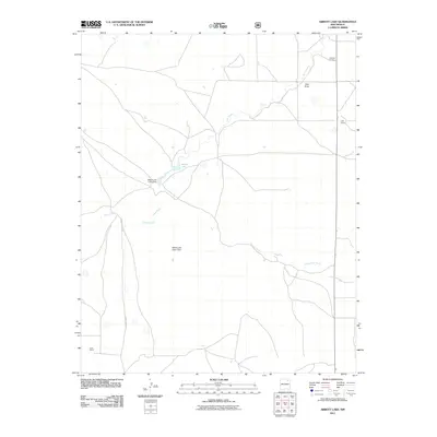
2011 Map of Abbott Lake
USGS Topo · Published 2011About this map
Sauz Creek and Salado Creek converge in this high-plains landscape of Colfax County, where the management of water is central to the local geography. The map highlights the infrastructure supporting Abbott Lake, specifically the Abbott Lake Lower Dam and the Abbott Lake Upper Dam. These man-made features, alongside the natural drainage of Alex Draw and Arroyo Ojo Verde, illustrate the critical role of water retention for the ranching operations that define this region.
Find a feature on this map
11 named features on this map. Tap any name to fly to it.
Don’t see what you’re looking for? This feature index may not catch every label — zoom into the map to look around manually.
Map Details
Editions of this 2011 Abbott Lake Map
This is the sole edition of this map. No revisions or reprints were ever made.
Other maps of this area

1954 · Raton
USGS Topo · 1:250,000

1958 · Raton
USGS Topo · 1:250,000

1965 · Taylor Springs
USGS Topo · 1:24,000

1965 · Abbott
USGS Topo · 1:24,000

1971 · Abbott Lake
USGS Topo · 1:24,000

1972 · Canon Colorado
USGS Topo · 1:24,000
1972 · Jaritas Ranch
USGS Topo · 1:24,000

1972 · Mills West
USGS Topo · 1:24,000
1974 · Mills East
USGS Topo · 1:24,000

1974 · Spear Hills
USGS Topo · 1:24,000