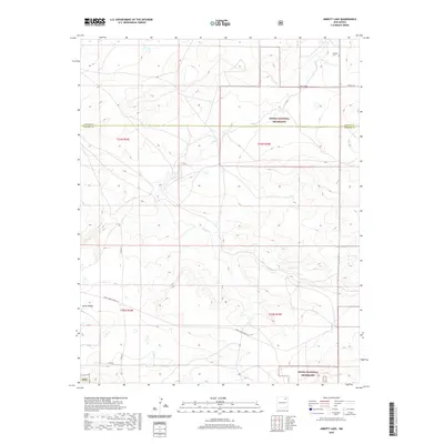
2020 Map of Abbott Lake
USGS Topo · Published 2020About this map
Kiowa National Grassland dominates this high plains landscape on the border of Colfax and Harding Counties. The terrain is defined by an intricate network of intermittent watercourses including Sauz Cr, Alex Draw, and Salado Cr that drain the arid ranchlands. In the northeast corner, the Johnson Cem serves as a lone marker of local family history, while the southwestern portion is characterized by the descent into Early Canyon. This 2020 survey illustrates the modern division of these traditional grazing lands through the Public Land Survey System, with the intersections of t23n r24e and t23n r25e meticulously recorded alongside contemporary ranch roads like Cross Canes Ranch Ln.
Find a feature on this map
16 named features on this map. Tap any name to fly to it.
Don’t see what you’re looking for? This feature index may not catch every label — zoom into the map to look around manually.
Map Details
Editions of this 2020 Abbott Lake Map
This is the sole edition of this map. No revisions or reprints were ever made.
Other maps of this area

1954 · Raton
USGS Topo · 1:250,000

1958 · Raton
USGS Topo · 1:250,000

1965 · Taylor Springs
USGS Topo · 1:24,000

1965 · Abbott
USGS Topo · 1:24,000

1971 · Abbott Lake
USGS Topo · 1:24,000

1972 · Canon Colorado
USGS Topo · 1:24,000
1972 · Jaritas Ranch
USGS Topo · 1:24,000

1972 · Mills West
USGS Topo · 1:24,000
1974 · Mills East
USGS Topo · 1:24,000

1974 · Spear Hills
USGS Topo · 1:24,000