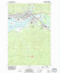
1957 Map of Aberdeen
USGS Topo · Published 1995About this map
The industrial and maritime core of Aberdeen dominates this landscape where the Wishkah River and Hoquiam River converge into the broad Grays Harbor. This 1957 field-checked survey reveals a busy hub of Pacific Northwest commerce, with the Burlington Northern railroad lines lacing through South Aberdeen and Cosmopolis to serve the local timber and shipping interests. The map documents the city's civic infrastructure, from the Olympic Stadium and Miller JR HS Weatherwax HS to the sprawling Grays Harbor College campus near the banks of Charley Creek. To the south, the terrain rises away from the tidal flats of Rennie Island and Cow Point into the drainages of the Johns River and Newskah Creek, where local landmarks like Books Ranch sit at the edge of the more traditional timberlands.
Find a feature on this map
59 named features on this map. Tap any name to fly to it.
Don’t see what you’re looking for? This feature index may not catch every label — zoom into the map to look around manually.
Map Details
Editions of this 1957 Aberdeen Map
This is the sole edition of this map. No revisions or reprints were ever made.
Other maps of this area

1940 · Montesano
USGS Topo · 1:62,500

1941 · Mobray
USGS Topo · 1:62,500

1943 · Humptulips
USGS Topo · 1:62,500

1943 · Mobray
USGS Topo · 1:62,500

1953 · Hoquiam
USGS Topo · 1:250,000

1955 · Montesano
USGS Topo · 1:62,500

1955 · Wynoochee Valley
USGS Topo · 1:62,500

1955 · Humptulips
USGS Topo · 1:62,500

1955 · Aberdeen SE
USGS Topo · 1:24,000

1956 · Western
USGS Topo · 1:24,000