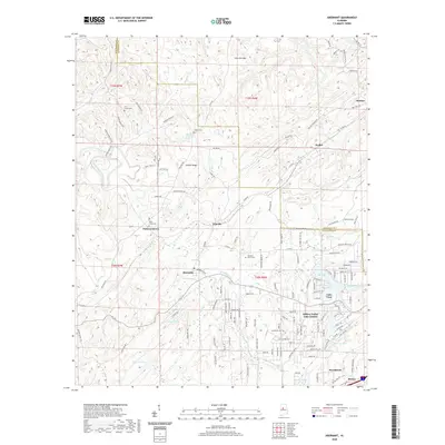
2020 Map of Abernant
USGS Topo · Published 2020About this map
Abernant and the surrounding borderlands of Tuscaloosa and Jefferson counties are defined by a complex network of ridges and water-carved valleys. The terrain is marked by prominent elevations like Cely Ann Mtn and Griffin Ridge, which overlook a series of small settlements and recreational water bodies. While older communities like Yolande and Pattersontown speak to the area's long-standing residential patterns, newer developments are evidenced by the intricate street grids of Million Dollar Lake Estates and the clustered waterfront properties near Ski Lake and Lake Number Seven. Genealogists will find significant value in the distribution of family-named landmarks and historical burial grounds, including Liberty Cem, Davis Creek Cem, and Pine Grove Cem. The landscape is tied together by numerous watercourses, from the winding Davis Creek to Kennedy Cr, reflecting a region where the natural topography continues to dictate the layout of roads and neighborhood boundaries.
Find a feature on this map
129 named features on this map. Tap any name to fly to it.
Don’t see what you’re looking for? This feature index may not catch every label — zoom into the map to look around manually.
Map Details
Editions of this 2020 Abernant Map
This is the sole edition of this map. No revisions or reprints were ever made.
Other maps of this area

1899 · Brookwood
USGS Topo · 1:125,000

1927 · Adger
USGS Topo · 1:48,000

1929 · Searles
USGS Topo · 1:48,000

1931 · Cottondale
USGS Topo · 1:48,000

1932 · Yolande
USGS Topo · 1:62,500

1934 · Searles
USGS Topo · 1:62,500

1934 · Cottondale
USGS Topo · 1:62,500

1934 · Blocton
USGS Topo · 1:48,000

1935 · Yolande
USGS Topo · 1:62,500

1940 · Blocton
USGS Topo · 1:62,500