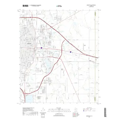
2019 Map of Abilene East
USGS Topo · Published 2019About this map
Abilene serves as the focal point of this 2019 survey, illustrating the city's modern layout and its eastward expansion toward the Taylor and Callahan county line. The landscape is defined by its aviation infrastructure and water management, featuring both the Abilene Regional Airport and the Abilene Municipal Airport. To the south, Kirby Lake and Lytle Lake provide significant hydrology for the region, while the northern reaches include the small settlement of Impact. Genealogy researchers will find several notable burial grounds, including Cedar Hill Cem, Old Colony Cem, and the specialized Abilene State Hospital Cem. The map captures the meeting of urban development and rural Texas prairie, with several residential streets in the south bearing whimsical names like Lollipop Trl and Sugarberry Ave near the industrial corridors along E Industrial Blvd.
Find a feature on this map
53 named features on this map. Tap any name to fly to it.
Don’t see what you’re looking for? This feature index may not catch every label — zoom into the map to look around manually.
Map Details
Editions of this 2019 Abilene East Map
This is the sole edition of this map. No revisions or reprints were ever made.
Other maps of this area

1890 · Abilene
USGS Topo · 1:125,000

1891 · Anson
USGS Topo · 1:125,000

1892 · Abilene
USGS Topo · 1:125,000

1893 · Anson
USGS Topo · 1:125,000

1954 · Abilene
USGS Topo · 1:250,000

1957 · Hawley
USGS Topo · 1:62,500

1957 · Kirby Lake
USGS Topo · 1:62,500

1957 · Abilene West
USGS Topo · 1:24,000

1957 · Abilene East
USGS Topo · 1:24,000

1957 · Nugent
USGS Topo · 1:62,500