1960 Map of Abingdon
USGS Topo · Published 1978About this map
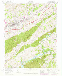
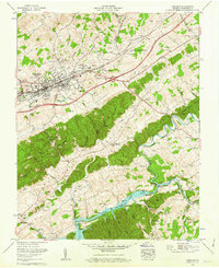
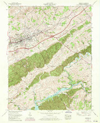
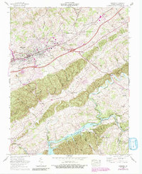
Abingdon serves as the focal point of this 1960s-era study, sitting at the junction of the Norfolk and Western rail lines and the Lee Highway. The landscape transitioning into the 1970s shows the suburban expansion of Scott Addition and Morningside Hills alongside established landmarks like the Fairground and the Glenrochie Country Club. Local history is deeply etched into the terrain through features like the Stone Mill and numerous family cemeteries such as Hagy Cem and Latture Cem.
Find a feature on this map
84 named features on this map. Tap any name to fly to it.
Don’t see what you’re looking for? This feature index may not catch every label — zoom into the map to look around manually.
Map Details
Editions of this 1960 Abingdon Map
4 editions found
Other maps of this area

1891 · Abingdon
USGS Topo · 1:125,000

1894 · Abingdon
USGS Topo · 1:125,000

1897 · Bristol
USGS Topo · 1:125,000

1902 · Bristol
USGS Topo · 1:125,000

1909 · Abingdon
USGS Topo · 1:96,000

1911 · Abingdon
USGS Topo · 1:125,000
1918 · Carterton
USGS Topo · 1:62,500

1934 · Holston Valley
USGS Topo · 1:24,000

1934 · Brumley
USGS Topo · 1:24,000
1934 · Wyndale
USGS Topo · 1:24,000