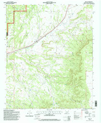
1995 Map of Abo
USGS Topo · Published 1998About this map
Salinas National Monument (Abo Division) preserves the cultural convergence of this high-desert landscape in Torrance County. The small settlement of Abo sits at the junction of significant drainage systems and canyon passages, including the wide Abo Arroyo and Cañon Barranco. The surrounding terrain within the Cibola National Forest is defined by an intricate network of deep canyons such as Cañon Latigo, Cañon Deer, and Cañon Saladito.
Find a feature on this map
28 named features on this map. Tap any name to fly to it.
Don’t see what you’re looking for? This feature index may not catch every label — zoom into the map to look around manually.
Map Details
Editions of this 1995 Abo Map
This is the sole edition of this map. No revisions or reprints were ever made.
Other maps of this area

1917 · Estancia
USGS Topo · 1:125,000

1954 · Torreon
USGS Topo · 1:62,500

1954 · Socorro
USGS Topo · 1:250,000

1956 · Mountainair
USGS Topo · 1:62,500

1958 · Socorro
USGS Topo · 1:250,000

1962 · Socorro
USGS Topo · 1:250,000

1972 · Chupadera
USGS Topo · 1:24,000

1972 · Bigbee Draw
USGS Topo · 1:24,000

1972 · Abo
USGS Topo · 1:24,000
1972 · Scholle
USGS Topo · 1:24,000