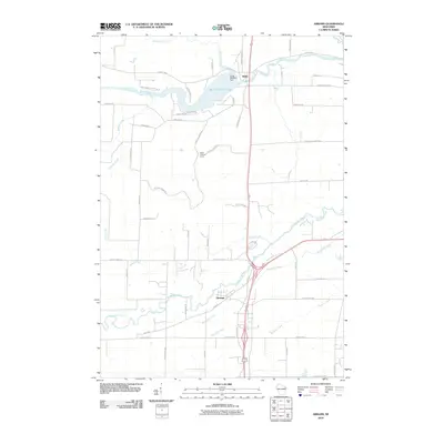
2010 Map of Abrams
USGS Topo · Published 2010About this map
Abrams and Stiles anchor this landscape along the river systems of Oconto County, where the Oconto River flows through the Machickanee Flowage near the Stiles 2WP550 Dam. The area is characterized by a dense network of watercourses, including the Pensaukee River, Brookside Creek, and Kirchner Creek, which define the drainage patterns south of the flowage. Significant elevation and survey points are noted by the presence of the Stiles Lookout Tower, situated between the primary settlements. The local road network, including family-named routes like Kruegers Quarry Rd, Liegeois Rd, and Chicken Shack Rd, reveals the transition from agricultural tracts to residential expansion. This 2010 survey reflects a period of modern rural development, tracing how the infrastructure of the Suamico area follows the natural contours of the various creek basins.
Find a feature on this map
59 named features on this map. Tap any name to fly to it.
Don’t see what you’re looking for? This feature index may not catch every label — zoom into the map to look around manually.
Map Details
Editions of this 2010 Abrams Map
This is the sole edition of this map. No revisions or reprints were ever made.
Other maps of this area

1954 · New Franken
USGS Topo · 1:62,500

1954 · Manitowoc
USGS Topo · 1:250,000

1954 · Green Bay
USGS Topo · 1:62,500

1955 · Green Bay
USGS Topo · 1:250,000

1956 · Oconto
USGS Topo · 1:62,500

1956 · Oconto Falls
USGS Topo · 1:62,500

1958 · Manitowoc
USGS Topo · 1:250,000

1974 · Abrams
USGS Topo · 1:24,000
1974 · Lena
USGS Topo · 1:24,000
1974 · Oconto Falls North
USGS Topo · 1:24,000