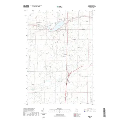
2018 Map of Abrams
USGS Topo · Published 2018About this map
The Machickanee Flowage, an expansive widening of the Oconto River, dominates the northern landscape near the settlement of Stiles. This river-driven topography is a central characteristic of the region, where numerous smaller tributaries like Splinter Cr and Brehmer Cr feed into the larger waterways. To the south, the village of Abrams sits at a crossroads of local transport, situated near the Pensaukee River and its accompanying drainages, including Brookside Cr and Kirchner Cr. The map's detail reveals a residential and agricultural network defined by named local lanes such as Chicken Shack Rd and Pioneer Park Rd, illustrating the modern rural development patterns that have formed around these historic Oconto County watercourses.
Find a feature on this map
86 named features on this map. Tap any name to fly to it.
Don’t see what you’re looking for? This feature index may not catch every label — zoom into the map to look around manually.
Map Details
Editions of this 2018 Abrams Map
This is the sole edition of this map. No revisions or reprints were ever made.
Other maps of this area

1954 · New Franken
USGS Topo · 1:62,500

1954 · Manitowoc
USGS Topo · 1:250,000

1954 · Green Bay
USGS Topo · 1:62,500

1955 · Green Bay
USGS Topo · 1:250,000

1956 · Oconto
USGS Topo · 1:62,500

1956 · Oconto Falls
USGS Topo · 1:62,500

1958 · Manitowoc
USGS Topo · 1:250,000

1974 · Abrams
USGS Topo · 1:24,000
1974 · Lena
USGS Topo · 1:24,000
1974 · Oconto Falls North
USGS Topo · 1:24,000