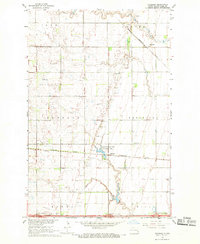
1967 Map of Absaraka
USGS Topo · Published 1969About this map
Absaraka sits at the intersection of prairie agriculture and the expansion of the northern rail network during the mid-1960s. This survey records the distinct landscape of Wheatland and Buffalo townships, where the Great Northern and Northern Pacific railroads traverse the plains. The map reveals an area defined by its logistical infrastructure, from the Larson Landing Strip to a series of highway crossings including the Ayr Interchange and Embden Interchange. Natural features like Swan Creek wind through the township boundaries of Ayr, Empire, Howes, and Gill. Notable for conservation and recreation, the Magnolia State Game Management Area is located near the settlement of Magnolia, providing a look at land use in Cass County before subsequent modern developments altered the rural character.
Find a feature on this map
19 named features on this map. Tap any name to fly to it.
Don’t see what you’re looking for? This feature index may not catch every label — zoom into the map to look around manually.
Map Details
Editions of this 1967 Absaraka Map
This is the sole edition of this map. No revisions or reprints were ever made.
Other maps of this area

1895 · Casselton
USGS Topo · 1:125,000

1897 · Tower
USGS Topo · 1:125,000

1897 · Casselton
USGS Topo · 1:125,000

1952 · Grand Forks
USGS Topo · 1:250,000

1953 · Fargo
USGS Topo · 1:250,000

1956 · Fargo
USGS Topo · 1:250,000

1956 · Grand Forks
USGS Topo · 1:250,000

1965 · Alice
USGS Topo · 1:24,000

1966 · Grand Forks
USGS Topo · 1:250,000

1967 · Page SE
USGS Topo · 1:24,000
Featured Places
- Wheatland Township, ND
- Howes Township, ND
- Buffalo Township, ND
- Gill Township, ND
- Absaraka, Empire Township