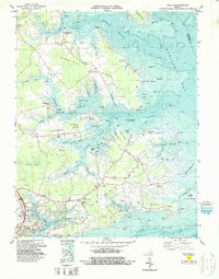
1983 Map of Achilles
USGS Topo · Published 1987About this map
The tidal necks of the Virginia Peninsula define this 1980s landscape, where the Ware River, Severn River, and York River carve deep into the Gloucester County coastline. Settlement is concentrated along the higher ground of Robins Neck and Guinea Neck, connected by a network of local roads leading to community hubs like Achilles, Bena, and Glass. The maritime character of the era is evident in the numerous maritime landmarks, from the Roues Wharf on the Ware River to Severn Wharf and the riverside communities of Gloucester Point and Gloucester Banks.
Find a feature on this map
90 named features on this map. Tap any name to fly to it.
Don’t see what you’re looking for? This feature index may not catch every label — zoom into the map to look around manually.
Map Details
Editions of this 1983 Achilles Map
2 editions found
Other maps of this area

1906 · Williamsburg
USGS Topo · 1:62,500

1907 · Yorktown
USGS Topo · 1:62,500

1907 · Hampton
USGS Topo · 1:62,500

1916 · Mathews
USGS Topo · 1:62,500

1917 · Mathews
USGS Topo · 1:62,500

1943 · Yorktown
USGS Topo · 1:62,500

1943 · Richmond
USGS Topo · 1:250,000

1944 · Yorktown
USGS Topo · 1:24,000

1944 · Messick
USGS Topo · 1:24,000

1944 · Harris Grove
USGS Topo · 1:24,000