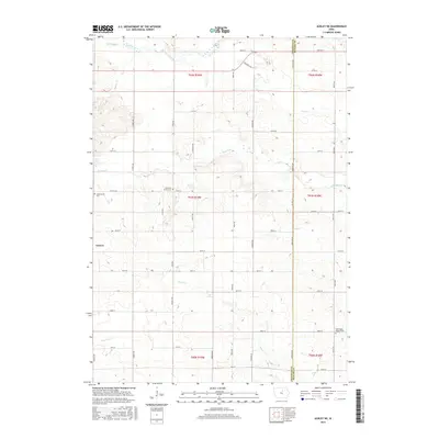
2015 Map of Ackley NE
USGS Topo · Published 2015About this map
Geneva anchors the western edge of this 2015 landscape, where the agricultural grid of northern Iowa is intersected by a complex network of waterways. The topography is defined by the drainage of Hartgrave Creek and its many tributaries, including Maynes Cr, Fockler Cr, and Johnson Cr. This hydrologic pattern influenced the placement of early infrastructure, seen in the winding path of Cemetery Dr as it follows the terrain north of Otter Creek. Genealogists will find three distinct burial sites preserved within this rural township structure: Lindenwood Cem to the west, Fourmile Grove Cem near the center, and Washington Reform Cem in the southeastern corner. The map illustrates the persistent divide between Franklin Co and Butler Co, showcasing how section lines and county roads like Co Hwy S56 and Co Hwy C51 continue to dictate the movement of people and goods across the prairie.
Find a feature on this map
45 named features on this map. Tap any name to fly to it.
Don’t see what you’re looking for? This feature index may not catch every label — zoom into the map to look around manually.
Map Details
Editions of this 2015 Ackley NE Map
This is the sole edition of this map. No revisions or reprints were ever made.
Other maps of this area

1954 · Waterloo
USGS Topo · 1:250,000

1955 · Waterloo
USGS Topo · 1:250,000

1972 · Dumont North
USGS Topo · 1:24,000

1972 · Hansell
USGS Topo · 1:24,000

1972 · Hampton North
USGS Topo · 1:24,000

1979 · Ackley NE
USGS Topo · 1:24,000

1979 · Ackley
USGS Topo · 1:24,000

1979 · Iowa Falls East
USGS Topo · 1:24,000
1979 · Hampton South
USGS Topo · 1:24,000

1979 · Dumont South
USGS Topo · 1:24,000