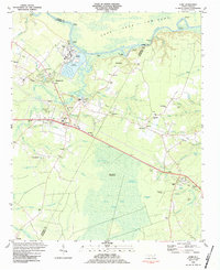
1984 Map of Acme
USGS Topo · Published 1984About this map
Industrial infrastructure and coastal lowlands define this 1980s landscape at the intersection of Columbus, Brunswick, and Pender Counties. Along the Cape Fear River, the area around Riegelwood and Acme features a concentration of heavy industry, including Industrial Waste Ponds, a Filtration Plant, and Sewage Disposal facilities. The Seaboard System Railroad serves as a primary transit corridor, connecting these riverside settlements with inland communities like Delco and Maco. To the south, the terrain transitions into the dense wetlands of the Little Green Swamp and Buckhorn Savanna, interrupted by family-named landmarks such as Chinnis Branch and Terrapin Branch. This era shows a community anchored by numerous rural congregations, including Bethel Church and Spring Green Church, alongside local education at the Acme-Delco School.
Find a feature on this map
79 named features on this map. Tap any name to fly to it.
Don’t see what you’re looking for? This feature index may not catch every label — zoom into the map to look around manually.
Map Details
Editions of this 1984 Acme Map
This is the sole edition of this map. No revisions or reprints were ever made.
Other maps of this area

1943 · Honey Island
USGS Topo · 1:24,000

1943 · Winnabow
USGS Topo · 1:24,000

1943 · Lewis Swamp
USGS Topo · 1:24,000

1944 · Winnabow
USGS Topo · 1:31,680

1944 · Lewis Swamp
USGS Topo · 1:31,680

1950 · Winnabow
USGS Topo · 1:25,000

1953 · Florence
USGS Topo · 1:250,000

1954 · Florence
USGS Topo · 1:250,000

1954 · Acme
USGS Topo · 1:62,500

1954 · Bolton
USGS Topo · 1:62,500