
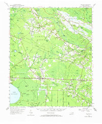
1954 Map of Bolton
USGS Topo · Published 1957About this map
The Cape Fear River and the sprawling Green Swamp dominate this mid-century portrait of the Bladen and Columbus County line. This area is defined by a unique hydrologic landscape of elliptical bays and blackwater runs, including Whites Bay Creek and Drunken Run Creek. The settlement pattern follows the high ground and the parallel corridors of the Atlantic Coast Line and Seaboard Air Line railroads, connecting towns like Bolton, Wananish, and Byrdville.
Find a feature on this map
68 named features on this map. Tap any name to fly to it.
Don’t see what you’re looking for? This feature index may not catch every label — zoom into the map to look around manually.
Map Details
Editions of this 1954 Bolton Map
2 editions found
Other maps of this area

1942 · Juniper Creek
USGS Topo · 1:24,000

1943 · Honey Island
USGS Topo · 1:24,000

1943 · Lewis Swamp
USGS Topo · 1:24,000

1944 · Lewis Swamp
USGS Topo · 1:31,680

1953 · Florence
USGS Topo · 1:250,000

1954 · Florence
USGS Topo · 1:250,000

1954 · White Lake
USGS Topo · 1:62,500

1954 · Acme
USGS Topo · 1:62,500

1955 · Whiteville
USGS Topo · 1:62,500

1955 · Atkinson
USGS Topo · 1:62,500