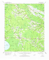
1954 Map of Bolton
USGS Topo · Published 1972About this map
The Cape Fear River and the Atlantic Coast Line define the landscape of eastern Columbus County in this mid-century survey. The terrain is a complex network of bays and swamps, where family names are etched into the geography at Kellys Cove and Lennon Cem. Along the river, Elwells Ferry and Locks Point indicate the historical importance of the waterway for transport, while the interior is dotted with rural centers such as Bolton and Freeman.
Find a feature on this map
120 named features on this map. Tap any name to fly to it.
Don’t see what you’re looking for? This feature index may not catch every label — zoom into the map to look around manually.
Map Details
Editions of this 1954 Bolton Map
2 editions found
Other maps of this area

1942 · Juniper Creek
USGS Topo · 1:24,000

1943 · Honey Island
USGS Topo · 1:24,000

1943 · Lewis Swamp
USGS Topo · 1:24,000

1944 · Lewis Swamp
USGS Topo · 1:31,680

1953 · Florence
USGS Topo · 1:250,000

1954 · Florence
USGS Topo · 1:250,000

1954 · White Lake
USGS Topo · 1:62,500

1954 · Acme
USGS Topo · 1:62,500

1954 · Bolton
USGS Topo · 1:62,500

1955 · Whiteville
USGS Topo · 1:62,500