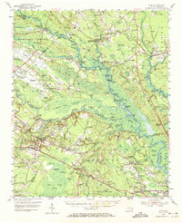
1954 Map of Acme
USGS Topo · Published 1972About this map
Moores Creek National Park and the serpentine Black River anchor this mid-century view of the coastal lowlands northwest of Wilmington. The landscape is defined by the shifting boundaries of the Cape Fear River and a dense network of river landings, including Roan Landing and Caintuck Landing, which once served as vital links for timber and local transport before modern highways fully bypassed the water.
Find a feature on this map
181 named features on this map. Tap any name to fly to it.
Don’t see what you’re looking for? This feature index may not catch every label — zoom into the map to look around manually.
Map Details
Editions of this 1954 Acme Map
2 editions found

Other maps of this area

1942 · Burgaw
USGS Topo · 1:62,500

1942 · Wilmington
USGS Topo · 1:62,500

1943 · Honey Island
USGS Topo · 1:24,000

1943 · Winnabow
USGS Topo · 1:24,000

1943 · Lewis Swamp
USGS Topo · 1:24,000

1944 · Winnabow
USGS Topo · 1:31,680

1944 · Lewis Swamp
USGS Topo · 1:31,680

1947 · Rocky Point
USGS Topo · 1:62,500

1948 · Wilmington
USGS Topo · 1:62,500

1950 · Winnabow
USGS Topo · 1:25,000