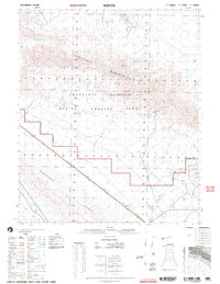
2002 Map of Acolita
USGS Topo · Published 2004About this map
Acolita sits at the intersection of desert infrastructure and military restriction in this early 2000s survey of Imperial County. The landscape is dominated by the Chocolate Mountain Aerial Gunnery Range, defined by a prominent Military Reservation Boundary that cordons off the jagged peaks of the Chocolate Mountains. In the southeast, the terrain shifts into the shifting sands of the Algodones Dunes and the flat expanse of East Mesa, where the East Mesa Canal introduces a linear human footprint into the arid environment. Local industry and historical activity are evidenced by the Black Eagle Mine and Mary Lode Mine in the northern uplands, while a Pumping Station and an underground pipeline trace the movement of resources across the desert floor near Mammoth Wash.
Find a feature on this map
23 named features on this map. Tap any name to fly to it.
Don’t see what you’re looking for? This feature index may not catch every label — zoom into the map to look around manually.
Map Details
Editions of this 2002 Acolita Map
This is the sole edition of this map. No revisions or reprints were ever made.
Other maps of this area

1903 · Yuma
USGS Topo · 1:125,000

1905 · Yuma
USGS Topo · 1:125,000

1907 · Holtville
USGS Topo · 1:125,000

1940 · Iris
USGS Topo · 1:62,500

1940 · Iris Pass
USGS Topo · 1:62,500

1940 · Alamorio
USGS Topo · 1:62,500

1942 · El Centro
USGS Topo · 1:250,000

1942 · Yuma
USGS Topo · 1:250,000

1942 · Blythe
USGS Topo · 1:250,000

1945 · Alamorio
USGS Topo · 1:62,500