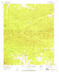
1958 Map of Acorn
USGS Topo · Published 1959About this map
The Ouachita National Forest dominates this landscape, where the ridges of Fourche Mountain and Blansett Ridge define the rugged topography of the Scott and Polk county line. In the late 1950s, the small settlement of Acorn sat at a vital junction where the Kansas City Southern railroad tracked alongside the upper Ouachita River. This intersection of rail and river reflects a quiet mountain economy, anchored by local institutions like Acorn Ch and the more isolated Union Grove Ch to the east. The terrain is marked by distinctive crossings and gaps, including Foran Gap and the nearby Foran Cem, providing clear evidence of early transport routes and family burial sites within the steep valleys carved by Cedar Creek and Johnson Creek.
Find a feature on this map
25 named features on this map. Tap any name to fly to it.
Don’t see what you’re looking for? This feature index may not catch every label — zoom into the map to look around manually.
Map Details
Editions of this 1958 Acorn Map
2 editions found
Other maps of this area

1879 · Poteau Mountain
USGS Topo · 1:62,500

1887 · Poteau Mountain #1
USGS Topo · 1:62,500

1887 · Poteau Mountain #2
USGS Topo · 1:62,500

1890 · Poteau Mountain
USGS Topo · 1:125,000

1899 · Poteau Mountain
USGS Topo · 1:125,000

1939 · Waldron
USGS Topo · 1:62,500

1940 · Waldron
USGS Topo · 1:62,500

1941 · Waldron
USGS Topo · 1:62,500

1949 · Waldron
USGS Topo · 1:62,500

1950 · Mcalester
USGS Topo · 1:250,000