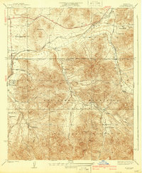
1939 Map of Acton
USGS Topo · Published 1939About this map
The Southern Pacific railroad corridor anchors this 1930s landscape, winding through the narrow floor of Soledad Canyon alongside the small settlements of Acton and Paris. This area of the San Gabriel Mountains shows a transition from the railway-dependent towns of the canyon floor to a high-elevation network of family ranching operations. Numerous named homesteads, such as the Maitre Smith Ranch, Strong Ranch, and Blum Ranch, are situated along canyon roads and mountain springs, indicating a period of localized land use before later suburban expansion. Much of the southern portion of the map is dominated by the Angeles National Forest, containing the CCC Camp and Werner Camp, which reflect the Depression-era public works and recreational infrastructure prevalent in the region during the mid-twentieth century.
Find a feature on this map
32 named features on this map. Tap any name to fly to it.
Don’t see what you’re looking for? This feature index may not catch every label — zoom into the map to look around manually.
Map Details
Editions of this 1939 Acton Map
3 editions found
Other maps of this area

1900 · Tujunga
USGS Topo · 1:62,500

1901 · Southern California Sheet No. 1
USGS Topo · 1:250,000

1904 · Southern California Sheet No. 1
USGS Topo · 1:250,000

1915 · Elizabeth Lake
USGS Topo · 1:125,000

1917 · Elizabeth Lake
USGS Topo · 1:125,000

1930 · Ravenna
USGS Topo · 1:24,000

1930 · Pearland
USGS Topo · 1:24,000

1932 · Red Rover
USGS Topo · 1:24,000

1932 · Palmdale
USGS Topo · 1:24,000

1934 · Pearland
USGS Topo · 1:24,000