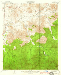
1939 Map of Acton
USGS Topo · Published 1939About this map
Soledad Canyon forms the primary corridor through this high desert landscape, carrying the Southern Pacific tracks and the Soledad Highway past a series of early twentieth-century homesteads and ranching outposts. This 1934 survey, published by Alfred Jones and the Los Angeles County Board of Supervisors, captures Acton as a vital railroad stop and community hub surrounded by family-named properties like the Strong Ranch, Maine Smith Ranch, and Blum Ranch.
Find a feature on this map
33 named features on this map. Tap any name to fly to it.
Don’t see what you’re looking for? This feature index may not catch every label — zoom into the map to look around manually.
Map Details
Editions of this 1939 Acton Map
3 editions found
Other maps of this area

1900 · Tujunga
USGS Topo · 1:62,500

1901 · Southern California Sheet No. 1
USGS Topo · 1:250,000

1904 · Southern California Sheet No. 1
USGS Topo · 1:250,000

1915 · Elizabeth Lake
USGS Topo · 1:125,000

1917 · Elizabeth Lake
USGS Topo · 1:125,000

1930 · Ravenna
USGS Topo · 1:24,000

1930 · Pearland
USGS Topo · 1:24,000

1932 · Red Rover
USGS Topo · 1:24,000

1932 · Palmdale
USGS Topo · 1:24,000

1934 · Pearland
USGS Topo · 1:24,000