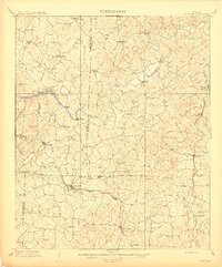
1909 Map of Acworth
USGS Topo · Published 1909About this map
Acworth and Kenesaw anchor the southern portion of this region during the first decade of the 1900s, positioned along the busy corridor of the Western and Atlantic RR. This era predates the large-scale impoundments that would later alter the local landscape, showing the Etowah River in its natural winding course. Movement across the river is facilitated by traditional crossings like Webster Ferry, Island Mills Ferry, and Galts Ferry, alongside early structures like Fields Bridge.
Find a feature on this map
59 named features on this map. Tap any name to fly to it.
Don’t see what you’re looking for? This feature index may not catch every label — zoom into the map to look around manually.
Map Details
Editions of this 1909 Acworth Map
This is the sole edition of this map. No revisions or reprints were ever made.
Other maps of this area

1888 · Atlanta
USGS Topo · 1:125,000

1890 · Suwanee
USGS Topo · 1:125,000

1890 · Cartersville
USGS Topo · 1:125,000

1890 · Atlanta
USGS Topo · 1:125,000

1891 · Marietta
USGS Topo · 1:125,000

1891 · Cartersville
USGS Topo · 1:125,000

1892 · Atlanta
USGS Topo · 1:125,000

1894 · Suwanee
USGS Topo · 1:125,000

1895 · Atlanta
USGS Topo · 1:125,000

1895 · Marietta
USGS Topo · 1:125,000