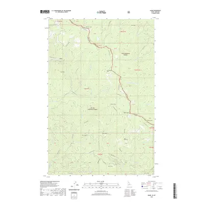
2020 Map of Adair
USGS Topo · Published 2020About this map
The settlement of Adair sits at a critical junction of mountain transport and forestry, where the Hiawatha Rail Trail follows the historic rail grade through the Bitterroot Mountains. This 2020 map documents the high-altitude terrain along the Montana-Idaho state line, marking the divide between the Lolo National Forest and St. Joe National Forest. The landscape is defined by a dense network of high peaks including Dominion Peak, Storm Peak, and Grays Peak, which overlook deep drainage basins for Burke Creek and Silver Creek.
Find a feature on this map
78 named features on this map. Tap any name to fly to it.
Don’t see what you’re looking for? This feature index may not catch every label — zoom into the map to look around manually.
Map Details
Editions of this 2020 Adair Map
This is the sole edition of this map. No revisions or reprints were ever made.
Other maps of this area

1914 · Avery
USGS Topo · 1:125,000

1917 · Avery
USGS Topo · 1:125,000

1918 · St Regis
USGS Topo · 1:125,000

1919 · St. Regis
USGS Topo · 1:125,000

1956 · Saltese
USGS Topo · 1:62,500

1956 · Wallace
USGS Topo · 1:250,000

1957 · Haugan
USGS Topo · 1:62,500

1957 · Simmons Peak
USGS Topo · 1:62,500

1960 · Wallace
USGS Topo · 1:250,000
1969 · Thor Mountain
USGS Topo · 1:24,000