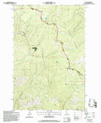
1995 Map of Adair
USGS Topo · Published 1997About this map
The rugged Bitterroot divide along the Idaho Montana state line is the focal point of this mid-1990s survey. Spanning the high-country boundary between St Joe National Forest and Lolo National Forest, the landscape is defined by steep drainages and prominent summits like Crittenden Peak and Dominion Peak. Evidence of the region's industrial past is visible near the Adair (Site) settlement, where the Old RR Grade winds through the mountains near several tunnels. Industrial activity and resource extraction are further highlighted by the presence of the Hecla Mines and various labeled Prospects and a Mine Shaft scattered across the ridges. Water resources are plentiful, with Mirror Lake and Silver Lake tucked into the high terrain above creeks such as Mineral Creek and Manhattan Creek.
Find a feature on this map
49 named features on this map. Tap any name to fly to it.
Don’t see what you’re looking for? This feature index may not catch every label — zoom into the map to look around manually.
Map Details
Editions of this 1995 Adair Map
This is the sole edition of this map. No revisions or reprints were ever made.
Other maps of this area

1914 · Avery
USGS Topo · 1:125,000

1917 · Avery
USGS Topo · 1:125,000

1918 · St Regis
USGS Topo · 1:125,000

1919 · St. Regis
USGS Topo · 1:125,000

1956 · Saltese
USGS Topo · 1:62,500

1956 · Wallace
USGS Topo · 1:250,000

1957 · Haugan
USGS Topo · 1:62,500

1957 · Simmons Peak
USGS Topo · 1:62,500

1960 · Wallace
USGS Topo · 1:250,000
1969 · Thor Mountain
USGS Topo · 1:24,000